

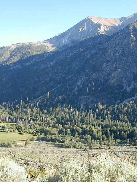
Inyo Forest Campgrounds – Eastern Sierra Campgrounds
areas include: Lone Pine, Mount Whitney, Independence, Onion Valley, Ancient Bristlecone Pines, Big Pine, Bishop [Hwy 168], High Sierra, Owens River, Lake Crowley, Rock Creek, Mammoth Lakes [Hwy 203], June Lake Loop [Hwy 158], Lee Vining & East Yosemite National Park [Hwy 120]. Camping on Eastern Sierra Highway 395
Eastern Sierra recreation – backpacking, horse packing, day hiking, creek fishing, mountain biking, mountaineering, rock climbing
Listed below are Inyo National Forest campgrounds, County Parks, BLM public camps for outdoor recreation. Many campgrounds are closed for winter months. Blue links lead to more camp information. Boldface links to detailed information & photos on campground.
| campground | elev | spots | veg | toilet | water | notes |
| Agnew Meadows | 8400′ | 21 | pines | chem | piped | Mammoth; Jun-Sept |
| Baker Creek Campground | 4100′ | 40 | cottn | vault | no | Big Pine, BLM; RV 30′ |
| Big Bend Campground | 7800′ | 17 | pines | vault | piped | Lee Vining, April-Oct |
| Big Meadow | 8600′ | 11 | pines | flush | piped | Rock Creek; May-Oct |
| Big Pine Creek | 9000′ | 30 | pines | vault | piped | W of Big Pine; May-Oct |
| Big Trees Campground | 7500′ | 9 | pines | flush | piped | W of Bishop ; April-Sept |
| Bishop Park Group Camp | 8400′ | 20 | pines | flush | piped | No RVs; Bishop Creek |
| Crowley Lake Camp | 6800′ | 47 | sage | vault | piped | BLM Camp; Apr-Oct |
| East Fork Campground | 9000′ | 133 | aspens | flush | piped | fishing camp Rock Creek |
| Ellery Lake Campground | 9500′ | 12 | pines | flush | piped | E Yosemite; June-Oct |
| Forks Campground | 7800′ | 8 | pines | flush | piped | W of Bishop,; April-Oct |
| Four Jefferey | 8100′ | 106 | pines | vault | piped | W of Bishop; April-Oct |
| Glacier View Campground | 4000′ | 40 | cttnwd | flush | piped | Big Pine, CA; open all yr |
| Goodale Creek | 4000′ | 43 | cttnwd | vault | no | BLM Camp; April-Nov |
| Grandview Campground | 8600′ | 26 | pinyon | vault | no | Ancient Bristlecone Pines |
| Grays Meadow | 6000′ | 52 | pines | flush | piped | W of Independence |
| Gull Lake Campground | 7600′ | 11 | aspens | flush | piped | June Loop; April-Nov |
| Hartley Springs | 8400′ | 20 | pines | vault | no | Glass Creek, June-Oct |
| Horseshoe Meadow | 10,000′ | 10 | pines | vault | piped | 1 day limit; horses; More |
| Horton Creek | 4975′ | 49 | pines | vault | piped | BLM Bishop; May-Oct |
| Independence Creek | 4000′ | 25 | cottn | vault | no | Independence, BLM; RV 30′ |
| Intake Campground | 7500′ | 8 | pines | flush | piped | W of Bishop; April-Oct |
| Iris Meadow Campgr | 8300′ | 14 | pines | flush | piped | W of Bishop; May-Oct |
| June Lake Campground | 7600′ | 22 | pines | flush | piped | fishing/hiking |
| Junction Campground | 9600′ | 13 | pines | vault | lake | E Yosemite; June-Oct |
| Lake George Campground | 9000 | 16 | pines | flush | piped | fish, June-Sept |
| Lone Pine Campground | 5500′ | 43 | pinyon | vault | piped | W of Hwy 395 |
| McGee Creek | 7600′ | 26 | aspen | flush | piped | Tom’s Place, Hwy 395 |
| New Shady Rest | 7800′ | 94 | pines | flush | piped | Mammoth, in town |
| North Lake Campground | 9500′ | 11 | pines | vault | piped | W of Bishop; June-Oct |
| Oh Ridge Campground | 6000′ | 148 | pines | flush | piped | June Lake |
| Old Shady Rest Camp | 7800′ | 51 | pines | flush | piped | Hwy 203, Mammoth |
| Onion Valley Campground | 9000′ | 15 | aspen | vault | piped | High Sierra access |
| Palisade Campground | 8600′ | 5 | aspen | flush | piped | Rock Creek; May-Oct |
| Pine City Campground | 8900′ | 10 | pines | flush | piped | Lake Mary, June-Sept |
| Pine Grove Campgr | 9300′ | 11 | pines | flush | piped | May-Oct |
| Pleasant Valley Res. | 4500′ | 75 | sage | vault | piped | BLM, US 395; open all yr |
| Pumice Flat | 7700′ | 17 | – | flush | piped | June-Sept |
| Reversed Creek Campground | 7600′ | 17 | aspen | flush | piped | June Loop; May-Oct |
| Rock Creek Lake | 7600′ | 25 | aspen | flush | piped | Tom’s Place; May-Oct |
| Sabrina Campground | 9000′ | 18 | pines | vault | piped | W of Bishop; May-Oct |
| Saddlebag Lake | 10,000′ | 20 | pines | vault | piped | highest camp; June-Oct |
| Sherwin Creek Camp | 7600′ | 87 | pines | flush | piped | Mammoth Lakes |
| Taboose Creek | 3900′ | 55 | shade | vault | stream | Big Pine; open all yr |
| Tinemaha Creek | 4400′ | 55 | shade | vault | stream | Independence, Inyo Co Park |
| Tioga Lake Campgr | 9700′ | 13 | pines | vault | piped | fish Yosemite, June-Oct |
| Tuff Campground | 7000′ | 34 | pines | flush | piped | Rock Creek; RV 22′ |
| Tuttle Creek | 5120′ | 83 | sage | vault | seasonal | Lone Pine; open all yr |
| Upper Pine Grove | 9400′ | 8 | pines | – | piped | May-Oct |
| Upper Sage Flat | 7600′ | 21 | pines | vault | piped | W Big Pine; April-Oct |
| Whitney Portal Camp | 9000′ | 44 | pines | flush | piped | Trailhead; May-Oct |
| Whitney Trailhead | 9000′ | 10 | pines | vault | piped | Trailhead; May-Oct |
see Group Campgrounds in Inyo National Forest, Eastern Sierra

Eastern Sierra Vacation, see also –
Topo maps, wilderness hiking maps, fishing maps
Equestrian trails, 4×4 routes, OHV maps –
- Inyo National Forest MAP
- Bishop Pass Trail Map
- Devils Postpile Hiking Map
- Dome Land Wilderness MAP
- Golden Trout Wilderness Map
- Hoover Wilderness Map
- Jawbone Canyon OHV MAP
- John Muir Wilderness Maps
- Kearsarge Pass Trail Map
- Kings Canyon High Country Map
- Mammoth High Country Map
 Eastern Sierra communities include:
- KENNEDY MEADOWS CA
- OLANCHA CA
- LONE PINE CA
- INDEPENDENCE
- BIG PINE CA
- BISHOP CA
- TOMS PLACE
- LAKE CROWLEY
- MAMMOTH LAKES
- JUNE LAKE CA
- LEE VINING CA
- WALKER, CA
- BRIDGEPORT, CA
- TWIN LAKES, CA

