San Diego Backcountry
600,000 acres of SoCal desert
BLOOM: mid-March thru May Anza Park elevations range from low to high. Lowest near eastern border (next to the Salton Sea) to the upper reaches of the western slopes @ 4000′. Wide, deep, sandy, long desert washes, native petroglphs, wind caves, slot canyons and split mountain. This uncrowded state park has the most acreages than all of the parks.
OPEN CAMPING
Camp in a developed campground, a small back country site or camp primitive on nearly any dirt road. Car camping to 4×4, this park has lots to offer folks wishing to really escape. No ground fires allowed, so bring your metal campfire bucket and large trash bag to carry out your ashes. The last thing you want is to scar these pristine white desert washes.
DESERT WILDFLOWERS
Steep rocky canyons on the Laguna mountain foothills can be challenging terrain, so bring good, sturdy hiking boots. Wildflowers can be abundant on certain years. Lower elevations sprout up first; Higher elevations along County Rd S-2 & S-22 bloom later in Spring. By June 1st most of the color is gone in and around Borrego Springs, so this is a real Winter and Spring vacation kinda spot. California desert wildflowers include primrose, barrel cactus, prickly pear, monkey flower, ocotillo & many more.
This is the largest State Park in California and “open car camping” is allowed on the back roads. (also referred to as primitive camping, free camping or 4×4 camping) One of the few places in Southern California that you can camp outside of a developed Campground and still have a campfire. You gotta bring a large metal bucket to have your campfire in – as ashes scar white sandy washes and ground fires are not allowed.
Mojave Reservoir @ Colorado River: AZ / NV / CA
@ the V, bottom of Nevada state = Arizona – Nevada – California, all merge together
The Colorado River travels through the southwest desert, splitting the Grand Canyon and further south, separating California from Arizona at the southern tip of Nevada. Agriculture lines the big river down to Baja, Sea of Cortez, Mexico.
Up near Las Vegas and down to Searchlight, NV
Above Hoover Dam is Lake Mead, sediment from Utah National Parks. Red dirt and silt shorelines. South of Hoover dam is a super deep rock gorge w/ hike-in hot springs. Beyond that, this beauty called Lake Mohave – with the super clear water, secluded coves and abundant fishing.
Lake Mohave: elevation 647′
Desert peaks in this region are around 2000-3000′ elevation. Mohave Lake is actually a wide section of the Colorado River, spanning the region from massive Black Canyon south to busy Laughlin w/ river casinos. This lake is long and skinny in spots with lots of shoreline cliffs, canyons and coves. Minimal vegetation, so please bring your own firewood and don’t chop down the few trees trying to survive. Summer temps exceed 100 degrees, so plan your visit for the winter time.
Lake Mohave Ranger Stations
Cottonwood Cove
Katherine Landing
boating, camping, fishing, hiking, hot springs, kayaking, off-road, picnics, viewpoints
El Dorado Canyon Road, main paved route can be accessed near California’s state border. North of Searchlight, Nevada – off main highway 95, on side route 165 to Nelson, NV
Secluded dirt roads up and down canyons near El Dorado Canyon Rd. Minimal vegetation, maximum open scenery and dark skies. Kayak rentals @ El Dorado Canyon.
desert badlands erosion
Ireteba Peaks Wilderness
4×4 camping routes: 15 day camping limit
Find your own route with many to choose from, drive the soft sandy washes (with a few boulders to dodge) and camp for free, right at the waters edge. Adventurers: Only for the self-contained campers. Some routes marked 4WD only, so pay attention to signs. AWD (all wheel drive) vehicles should fare well on the sandy roads; but standard passenger cars and vans will need to keep their speed up in the soft sand areas.
No garbage collection. Pack it in, pack it out.
No facilities, no fees. No buildings. No campfire rings, no picnic tables, very few vault toilets. Bring your shovel!
Driving off the roads is strictly prohibited. Primitive camp sites can be found both at numerous coves and also inland inside the canyons. The ridges get windy in the deserts, but are favorable for night sky views and self contained camper vans.
Always know the weather forecast, cuz flash floods are possible and these dirt roads will be impassible during big rain. This is the main drainage to the big river!
DRIVING TIPS
Most desert washes here are signed routes 4×4, but mini vans, AWD sport-wagons, trucks, SUVs, small RVs can all be found camping near Lake Mohave. That is – if you know how to ‘drive off road’, which is not fast, but not too slow either.
Avoid getting stuck in the deep sand: keep speed up, do not turn sharply and do not brake hard. Carry tow strap in case you need an emergency pull. Be nice to strangers and you may find help.
Campfires are allowed, but you need to bring firewood. Dogs are allowed. Party animals tend to trash these desert coves, so be warned that there is a fair amount of litter. Bring a black trash bag and take some out! This trash problem could get the area closed off to vehicles so keep that in mind.
The canyons here have giant power lines that cross @ Aztec Wash; they can easily be avoided.
4×4 recommended @ MOHAVE:
Eagle Wash Road #46 – popular spot
Montana Wash #45 – camping ok
Placer Wash #47 – no camping
The rangers don’t wanna be pulling your ass out of the sand, which is why they post the 4×4 signs. Don’t expect to find help without walking a few miles first, or waiting several hours.
desert wilderness
Several wilderness areas are located along the west side of this lake & river. Often dirt roads will parallel a portion of the wilderness boundary, providing excellent access to secluded coves and beaches. Emergency CALL boxes are placed in remote parts of these shores.
Ireteba Peaks Wilderness (northwest, next to El Dorado Canyon)
Nellis Wash Wilderness (western side)
Spirit Mountain Wilderness (southwest)
Bridge Canyon Wilderness (southwest, near Laughlin)
COTTONWOOD COVE
developed campground, boat launch, marina, lodging, hiking, picnic areas
LAUGHLIN, NV
Nevada, California and Arizona states join down in this part of the world. Katherine Landing, full service marina, slip rentals, lodging, city services and casinos.
Mojave Desert – This river-created lake is located on the Colorado River, in between Las Vegas, Nevada and Needles, California. The river water here is crystal clear, very swimmable and the fishing is decent. No paved boat ramps
nearby towns: (with elevation)
Avi Casino
Bullhead City, AZ (540′)
Laughlin, NV (535′)
Kingman, AZ (3340′)
Needles, CA
Nelson, NV (2954′) Nipton, CA (3042′) Oatman, AZ
Searchlight, NV (3470′)
Horse Canyon is a dirt road up a high desert canyon, with joshua trees and wash outs. 7000′ elevation pinyon pine ridges above w/ PCT.
Most would say the see a whole-lotta-nothingness out here in these deserts…. when they zoom by at 70 mph on the blacktop highway.
at Total Escape, we beg to differ.
Intersection on Hwy 14 @ SC 65, dirt route will travel west into the mountains. Initial desert road follows Little Dixie Wash, but veers north up to Horse Canyon and the higher forested ridges.
Horse Cyn is a scenic, desert, dirt road that becomes a rugged 4×4 trail the higher it climbs in the canyon. The route traverses a ridge line and dead ends at the old cabin; No through route, no loop. The PCT continues on to the Walker Pass @ the 178.
The lower Horse Canyon is area quite accessible by standard truck or SUV. High clearance is recommended out on these kinda roads. Vegetation is quite sparse at first, but improves with the miles traveled. Wildflowers can be awesome, usually April-June. Picnic spots everywhere; primitive camping sites can be found out here, off the main dirt road. Please reuse existing camp sites when possible.
Passenger cars may attempt this, but should watch for unexpected deep dips and rocks, washed out in the road. (No tow service in the middle of nowhere). Road conditions do change with the seasons out in the boonies. Cell phone reception could be spotty back in the deepest of canyons.
PCT trail access: Pacific Crest Trail follows this ridge road for miles. They call this range the SCODIE Mountains; Old cabin at the end of the road.
Sage Canyon and Cow Heaven Canyon are both to the north, along with Freeman Canyon (CA SR 178). Bird Spring and Dove Spring Canyons are both to the south, along with the most popular regions of Red Rock State Park and the Jawbone OHV area.
came to California for college and never left
Some folks would argue that education through life experiences can be just as rewarding as following the traditional path of private schools or state education. The internet is fast replacing the need for formal education, as many entrepreneurs never graduate from college and still go on to become huge successes.
Going to university or college in California is a common path for many students, which is why there are mostly transplants living on the west coast. Many start at community colleges and transfer to a 4 year college.
California is the largest state in the union, as well as the most prosperous. California has the one of the largest economy in the world!
Below is a list of California cities and towns with a big student population. Some of these places have more than one college or university in town. IN and around town you will find abundant apartment living, cafes, coffee shops, mexican food, laundromats, bike paths, parks and public bus service.
The New York Fed’s second quarter numbers are out for 2016 and it doesn’t paint a pretty picture for student loan debt. Officially, the nation owes $1.26 trillion in student loan debt. Realistically, we are probably over the $1.3 trillion mark when taking into account the fact that the Fall semester has just started…
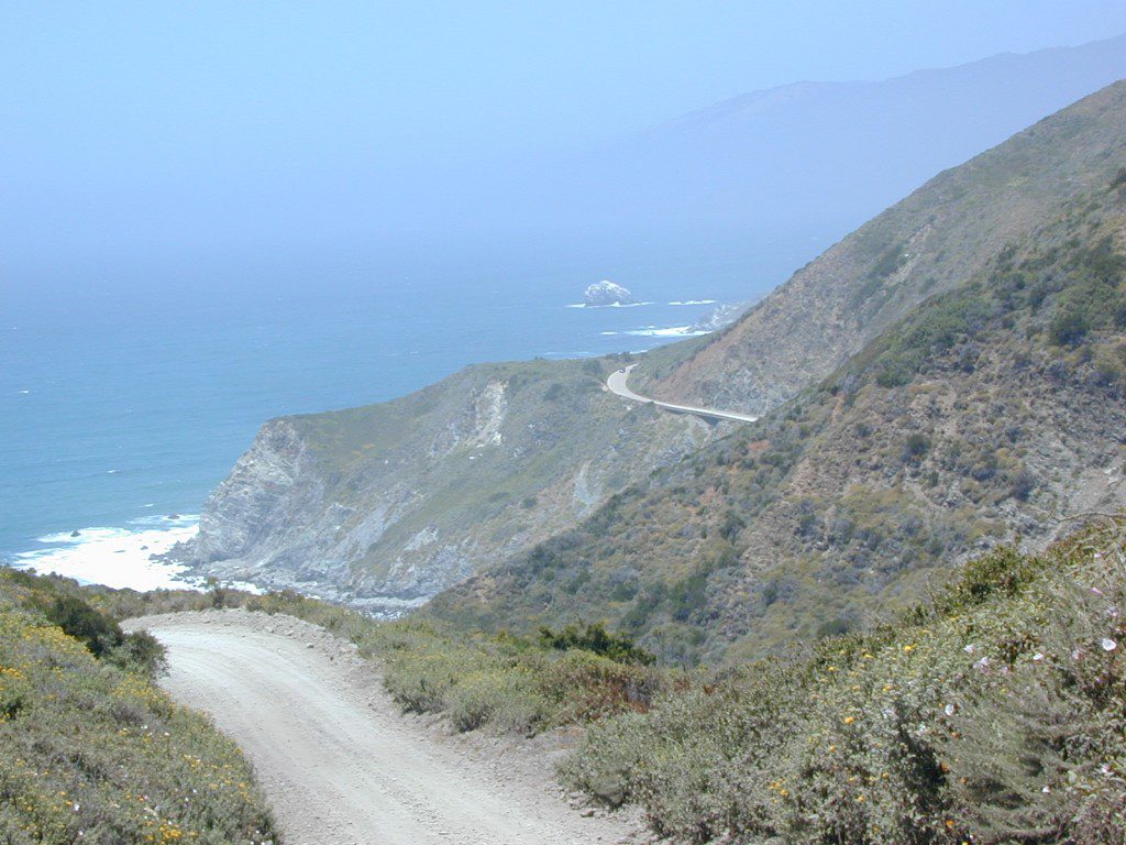
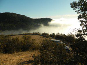
South Big Sur Coast Dirt Roads & super scenic US HWY 1 – North of San Simeon and Hearst Castle, north of Ragged Point and just past Gorda, CA a dirt shoulder, widens, a break in the bushes on the right side of the highway, a small wooden sign for the Yurt Resort called Treebones and the turn off to the back-country of Los Padres National Forest Road #23S01
Willow Creek is a steep coastal canyon w/ Willow Creek Trail #5E08 in the creek below and the dirt road 1000′ above. Willow Creek Day Use Area, the Willow Creek bridge and Willow Creek beach w/ restrooms, picnic tables, and paved parking lot near the highway.
DIRT ROAD, high clearance is recommended, but not required. 4×4 may be needed in wet weather. Motorhomes, trucks w/ trailers and RV campers are not gonna like this rugged, narrow, steep, dirt road and are advised to stick to the pavement. Camper vans and SUVs are be better suited for this terrain.
Yahoo Maps has this route as Willow Creek – Los Burros Road
Mapquest has this one listed as Los Burros Rd – Fort Hunter Liggett(which is a military base, on the opposite side of the mountain range near US Hwy 101)
Several primitive camp sites can be found along this rugged dirt road, which climbs steeply and switchbacks thru redwoods, madrones, cedars, grass lands and oak hills. Sites within the first 3 miles of this road offer the serene sounds of the ocean – waves, seals, sea lions as well as traffic on the busy highway. There are a few private properties back here in the boonies too, so read signs and don’t go exploring this region in the dark.
About 8 miles back on Willow Creek Rd is Alder Creek Campground – a small developed camp w/ only 2 camp sites and no piped water and no fees.
Prewitt Ridge also has numerous ideal top-of-the-world, free camp sites, which do require a lot more dirt road driving and a very good backcountry map.
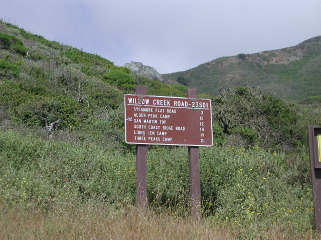
Sycamore Flat Road intersects @ 3 miles up
Alder Peak Camp is San Martin Top @ 12 miles up
South Coast Ridge Road is at the very top @ 14 miles
If you want trees in your Death Valley visit, than this is it. Mahogany Flats Campground is located in a juniper forest on a ridge line of the Panamint Mountains. Often windy camp sites with the highest elevation campground in the area. If you seek to get away from the desert heat, this may be the best option. Spectacular views to the east, over the Death Valley basin. Access to hiking, backpacking, off roading, mountaineering opportunities. A great place to escape summer heat, but be warned of thunderstorms. Picnic table, fire ring, pit toilets – maintained with NPS.
Elevation: 8,133′
Number of Sites: 10
Vehicle Accessibility: High Clearance, recommended. No RVs or trailers. 4×4 needed in heavy rain or snow.
Campsites Reservation: No
Length of Stay: 30 Days
Season: March – November
Trailheads: Telescope Peak & Tuber Canyon
Directions:
From Stovepipe Wells, follow Highway 190 W to Emigrant Canyon. Turn left on Wildrose Road and follow it thru the tight rocky canyon, climbing in elevation the whole way.
Passing Wildrose Campground where the pavement ends, past charcoal kilns, climbing in elevation past the pinyon pines at Thorndike Campground, up, up, way up Mahogany Flat Road.
From Panamint Valley, take Wildrose Road up. Turn right to Mahogany Flat Rd and proceed on the dirt road to the top.
The Telescope Peak mountain range is the only place in the lower 48, where you can see both the tallest peak (Mt Whitney) and the lowest point (Badwater Death Valley).
NorCal Hiking
Castle Crags State Park
CastleCrags Wilderness
12,232 acres
Northern California Mountains
South of Dunsmuir, CA Interstate 5
exit #724 – Castella
backpacking, camping, creek fishing, hiking, mountaineering, lakes, rock climbing, snowshoeing, swimming, waterfalls
About an hour north of Redding, you can see those impressive peaks off to the left above the lush forest. Way up off the west side of I-5, lies a hiking paradise of scenic lakes, waterfalls and wildflowers. Opposite the freeway from Mount Shasta; Just south of Lake Siskiyou.
Castle Crags Wilderness neighbors the Castle Crags State Park, which is surrounded by Shasta-Trinity National Forest. This area is named for 6,000′ tall glacier-polished peaks and pointed crags. Due to their relatively low elevation, year-round recreation, hiking, backpacking, and rock climbing are popular spring through fall. Snowshoeing near Castle Lake is excellent.
Castle Crags State Park Campground
76 developed campsites
6 environmental campsites
Max Camper Length: 27′
Max Trailer Length: 21′
28 miles of hiking trails (2.7 mi access trail to Castle Crags Wilderness)
The Pacific Crest Trail also passes through the park.
Dogs not allowed on park trails.
regional history:The northwest area contains the largest glacial cirque, Castle Lake, which is near where the Modoc War’s 1855 Battle of Castle Crags took place. Now a historical landmark, the battle was fought on a ridge saddle between the lake and what is known as Battle Rock. The Wintu tribe inhabited the area, they called the crags the Abode of the Devil and the Spanish explorers called it Castle del Diablo (Castle of the Devil.) read more on wiki
Kern County is known for its oil, its agriculture, and outdoor recreation. The Kern River is the highlight of the region with lush, green and grey granite canyons, a big reservoir & the Sequoia trees just up the road. On the western side of Kern County are small towns like Frazier Park, the golfing cabin community of Pine Mountain Club, plus the oil meccas of Maricopa and Taft. Expansive Lockwood Valley enters into Ventura County. Cuyama River borders Santa Barbara & SLO counties.
The 17 mile long Quatal Canyon, where the indian camp of Mahu Tasen hosts a Bear Dance every summer is also a wild place of bird watching, camping and hunting. The indian word for Mount Pinos is “Iwihinmu” – a sacred spot for Chumash Indians, as well as others; Chumash call it the ‘center of the world’. Locals respond regularly with music, hikes, star gazing, drum circles (seasonally) and local festivals (annually) .
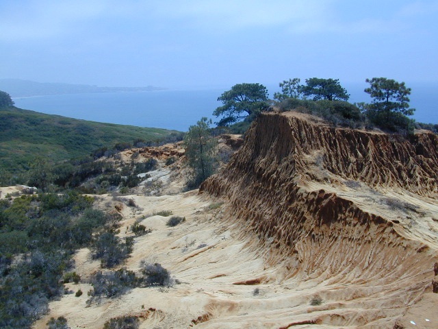
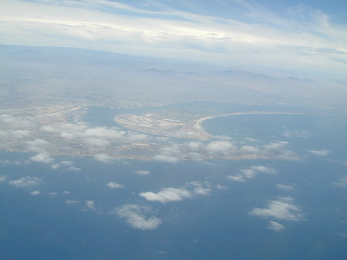
Torrey Pines State Reserve is in San Diego County – just south of Del Mar CA. Easy access from I-5 & perfect for hikers seeking exercise – instead of sitting in traffic on the freeway. The point you see in the distance is La Jolla.
Ocean, cliffs, pines, beaches & sunny San Diego weather.
What could be better for an after work stroll?
There are numerous pine forest groves, with hiking trails leading down the cliffs to tide pools & beautiful beaches. You could easily spend a whole day exploring this coastal park. There is a Visitor Center, guided nature walks & paved parking lots. The lagoon region has a train track running through the valley east of it – and the tracks meet the coast nearby. The rocky beach to the north is very popular with surfers & there is even surfing contest held here annually. Plenty parking along this stretch too. If you wanna avoid the park fees, you can park along PCH (Pacific Coast Highway) & walk the beach to the south. The cliffs make for seclusion & many sunbathers love this area.
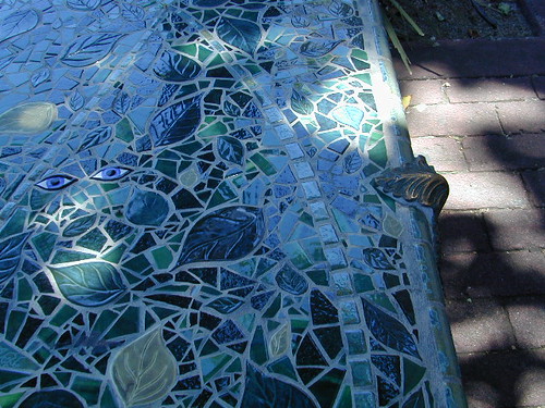
On occasion, if the conditions are right, the San Diego RED TIDE will appear, which can only be seen at night. The kelp beds glow with sparkles of green & blue light (not red) w/ the phytoplankton …..as the waves come crashing toward the shoreline. More info on red tides on Wikipedia


 Lake Mohave Ranger Stations


 Directions: