Category Archives: Snow

Tahoe Lake Map

Tahoe Maps: trail maps

lake camp, hike, mountain bike, off-road, ski, snowmobile

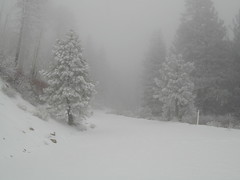
Tahoe Trail Maps / Tahoe National Forest

tahoe hiking maps

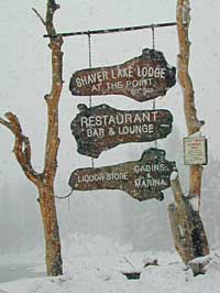
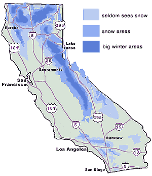
Numerous State Parks dot the shoreline at Tahoe, while the National Forest lands and Wilderness Areas span most of the peaks above. Camping, backpacking, boating, kayaking, fishing, climbing, mountaineering, mountain biking, snow skiing, snowmobiling are all popular recreation in this Sierra region. US Highway 50 and Interstate 80 are the main western access routes to Lake Tahoe. US Hwy 395 leads to Tahoe, up from the Eastern Sierra and Southern California.

Wanna find every waterfall or every creek to fish? This is the place that will help you find them. Easily, with good old fashion printed maps. Hard copies, some waterproof & tear resistant, most with topographical data and all roads, trails, campgrounds and parks. Whether or not you water ski or cross country ski, these maps will save your ass – when you are way back there in the boonies.

Tahoe’s Rubicon Trail connects the historic Gold Country to the alpine lake via granite wilderness sky ways above 7000′ elevation, but a real 4×4 and overnights are required. The back roads and trails are endless in these parts of the Central Sierra Nevada mountains.tahoe maps

keep tahoe blue

Nearby attractions surrounding Lake Tahoe –

Tahoe National Forest
Tahoe Rim Trail
Rubicon 4×4 Trail
Lakes Basin Recreation Area
Sierra Buttes
Desolation Wilderness
Grover Hot Springs
Blue Lakes
Hope Valley

cabin rentals

San Jacinto Wilderness

Jacinto Maps

Southern California / San Jacinto Wilderness Area / San Jacinto Mountain / Palm Springs Mountain Hike

The well-photographed snowy mountain backdrop behind the desert deluxe resort-land known as Palm Springs, Mount San Jacinto is the second tallest peak in Southern Cal.

Mighty San Gorgonio peak, across to the east – on the other side of the valley, is the very highest mountain in this desert region. Granite Jacinto peak is located in between the mountains of Idyllwild and the low deserts of Palm Springs.

32,248 acres

Mount San Jacinto – 10,834′ elevation

San Bernardino National Forest

JACINTO PARK access –

Palm Springs via Tram

Book tickets online!

Nearest towns:
Idyllwild CA
Pine Cove CA

jacinto peak

Day hikes, picnic in the forest, backpacking, horseback rodes w/ SUPER easy access via the fantastic Palm Spring Tram ride, up to 8000′ elevation.

The San Jacinto Wilderness is managed by 2 different agencies: The National Forest Service and California Department of Parks & Recreation.

If you are camping overnight in the forest, you must get your wilderness permit from the agency that administers the area where you plan to spend the night. Day-use permits can be obtained on the day of your trip by visiting one of the ranger stations below. Day-use permits issued by either agency are honored by both, except during the busy summer months when permits to enter the Wilderness via Devil’s Slide Trail can be obtained only from the National Forest Service.

Camping permits can be obtained in advance by mail, in person, or online w/ PDF. National Forest Service accepts requests up to 90 days in advance; Mount San Jacinto State Park accepts them up to 56 days in advance. You can also get them on the day of your trip, if any are available at that time.


USDA National Forest Service
San Jacinto Ranger District
54270 Pine Crest Ave
Idyllwild, CA 92549
951-659-2117

Mount San Jacinto State Wilderness
25905 Highway 243
Idyllwild, CA 92549
951-659-2607

regional trail maps –

San Jacinto Hiking Maps

Mount San Jacinto State Park is surrounded by San Jacinto Wilderness

More San Jacinto Wilderness Info & Links –

summitpost.org/jacinto-peak
San Jacinto Peak Wiki
USDA San Jacinto Wilderness
Mount San Jacinto State Park

Bucks Lake Wilderness

DSCN0237

Bucks Lake Wilderness Area

Bucks Lake, California
Plumas National Forest

topo mapIn the hills and canyons above Chico many wonders can be found. North Sierra Nevada mountains, medium sized recreation lake surrounded by lush forest; N of Lake Oroville and S of Lake Almanor. North Fork Feather River canyon forms the northern boundary to this designated Wilderness Area. The area is popular with backpackers and PCT hikers, as well as equestrian and the region has over a dozen campgrounds. Backcountry terrain includes an impressive 6 mile long canyon wall.

camp Bucks Lake Campgrounds

hotels Bucks Lake Lodging

The popular boating destination, Bucks Lake reservoir, is just outside the wilderness boundary, which makes for an excellent destination for day hikes. Boating, fishing, backpacking, hiking, camping, canoeing, kayaking, rock climbing, snowmobiling and mountain biking are just some of the outdoor recreation in the area. This Wilderness region features a Silver Lake and Gold Lake, as well as numerous other small, unheard-of lakes. A few can be accessed by vehicle, but more than half are hike-in only lakes.

  • backpacking
  • boating
  • cabin rentals
  • camping
  • canoeing
  • fishing
  • floating
  • hiking
  • kayaking
  • sailing
  • swimming
  • Bucks Lake Wilderness
    23,958 acres
    5200′ elevation at Bucks Lake

    Alpine wilderness, mountain peaks, hiking trails, PCT trailheads, numerous small lakes, plus large recreational fishing lake

    Bald Eagle Mountain – 7183′
    Bucks Mountain Peak – 6819′
    Mount Pleasant – 7067′

    Small lakes around the Bucks Lake Wilderness Area

    Bald Eagle Lake
    Blue Lake
    Cape Lake
    Gold Lake
    Grassy Lakes
    Jacks Meadow Pond
    Kellogg Lake
    Lost Lake
    Mud Lake
    Rock Lake
    Silver Lake
    Snake Lake
    Smith Lake
    Thompson Lake
    Three Lakes
    Upper Mud Lake

    regional maps –

    nearby towns –
    Berry Creek, CA
    Meadow Valley, CA
    Quincy, CA
    Chico, CA
    Oroville, CA

    lodge and cabins
    historic lodge burnt down, but they rebuilt and are re-opened again

    DSCN0242

    more info –

    Bucks Lake Trailheads (PDF)
    BucksLake.net
    Bucks Lake Fire Dept
    Bucks Lake Wilderness Wiki


    View Larger Map

    Sierra Road Conditions

    Sierra Nevada Road Conditions – Highway California

    Snowy RoadsWinter Snow/ Winter Roads Sierra Nevada:

    On rare occasions the Golden State freeway – Interstate 5 can be closed due to snow; N of Valencia on the Grapevine (near Lebec) or more likely up in NorCal (near Shasta).

    Interstate 80 (aka Donner Pass) is often closed during big storms. Luckily there are hotels in Auburn or Truckee.

    Highway conditions on mountain passes higher than 4000′ elevation can be unpredictable in winter months (Oct-May). It may be fine & just sprinkling @ 2000′, but a few miles up can be a white out. Ask anyone who’s ever driven the infamous Donner Pass in winter time. (more on Donner Party)

    Annual Sierra Highway Closures

    Ski mountains

    shaver lakeWhere does it Snow in California ?
    Okay, okay ….so it’s nothing like those dreaded East Coast winters, but hey, some parts of California do get some serious snow. (see elevations) And the newbies who don’t prepare for it will be sorry. On the winter vacation travels, be prepared for almost anything, especially in the Sierra’s & Northern California.
    Snowy towns in California

    See California Weather & Road Conditions

    California Winter: When does winter actually ‘set in’ for California?

    Eastern Sierra CA: OCT- MAY
    Western Sierra CA: NOV- APR
    High Sierra CA: SEPT- MAY
    North Coast CA: OCT- MAY
    Northeast CA: OCT- APR

    The following mountain roads are partially closed or totally closed during winter months. Please check road conditions before you leave for your trip. Chains may be required in most mountain areas of California.

    CALTRANS web site

    Highway CA County Region Connecting Towns
    Hwy 155 Kern Southern Sierra Alta SierraWofford Heights
    Hwy 190 Tulare Western Divide Hwy Camp NelsonPonderosa CA
    M 375 Tulare Sequoia NP Hammond – Mineral King
    Hwy 180 Tulare Kings Canyon NP Hume Lake – Cedar Grove
    Whitney Portal Rd Inyo Eastern Sierra Lone Pine – Mount Whitney
    Onion Valley Road Inyo Eastern Sierra Independence – Onion Valley
    Glacier Lodge Rd Inyo Eastern Sierra Big Pine – Glacier Lodge
    Lake Rd Hwy 168 Inyo Bishop Area Hwy 168 – South Lake
    Hwy 120 Mariposa Yosemite NP Yosemite Lee Vining CA
    Hwy 120 Mono Mono Lake Lee ViningBenton Hot Springs
    Hwy 108 Mono Eastern Sierra DardenelleSonora Jct. Hwy.395
    Hwy 89 Alpine Eastern Sierra MarkleevilleLake Topaz
    Hwy 4 Alpine South Lake Tahoe Lake Alpine – Hwy 89
    Hwy 44 Shasta Lassen Volcanic NP Manzanita Lake – Mineral CA

    Castle Crags Wilderness

    NorCal Hiking
    Castle Crags State Park
    CastleCrags Wilderness

    12,232 acres
    Northern California Mountains
    South of Dunsmuir, CA
    Interstate 5
    exit #724 – Castella

    backpacking, camping, creek fishing, hiking, mountaineering, lakes, rock climbing, snowshoeing, swimming, waterfalls

    About an hour north of Redding, you can see those impressive peaks off to the left above the lush forest. Way up off the west side of I-5, lies a hiking paradise of scenic lakes, waterfalls and wildflowers. Opposite the freeway from Mount Shasta; Just south of Lake Siskiyou.castle crags

    Castle Crags Wilderness neighbors the Castle Crags State Park, which is surrounded by Shasta-Trinity National Forest. This area is named for 6,000′ tall glacier-polished peaks and pointed crags. Due to their relatively low elevation, year-round recreation, hiking, backpacking, and rock climbing are popular spring through fall. Snowshoeing near Castle Lake is excellent.

    Castle Crags State Park
    530-235-2684

    Castle Crags State Park Campground
    76 developed campsites
    6 environmental campsites

    Max Camper Length: 27′
    Max Trailer Length: 21′

    28 miles of hiking trails (2.7 mi access trail to Castle Crags Wilderness)
    The Pacific Crest Trail also passes through the park.
    Dogs not allowed on park trails.

    Shasta-Trinity National Forest
    Mount Shasta Ranger District
    204 West Alma
    Mt. Shasta, CA 96067
    530-926-4511

    Climbing at the Crags:
    the Cosmic Wall & beyond

    regional history: The northwest area contains the largest glacial cirque, Castle Lake, which is near where the Modoc War’s 1855 Battle of Castle Crags took place. Now a historical landmark, the battle was fought on a ridge saddle between the lake and what is known as Battle Rock. The Wintu tribe inhabited the area, they called the crags the Abode of the Devil and the Spanish explorers called it Castle del Diablo (Castle of the Devil.) read more on wiki

    nearby towns –


    View Larger Map

    West Kern

    festivals kern

    CA Kern / western Kern county

    Kern County is known for its oil, its agriculture, and outdoor recreation. The Kern River is the highlight of the region with lush, green and grey granite canyons, a big reservoir & the Sequoia trees just up the road. On the western side of Kern County are small towns like Frazier Park, the golfing cabin community of Pine Mountain Club, plus the oil meccas of Maricopa and Taft. Expansive Lockwood Valley enters into Ventura County. Cuyama River borders Santa Barbara & SLO counties.

    Much of the western Kern area is rural ranch land, desert or forest. Los Padres National Forest, Chumash Wilderness, Bittercreek Wildlife Refuge, Wind Wolves Preserve, Buena Vista Reservoir, Ballinger Canyon, Hungry Valley and Fort Tejon State Park all call this region home, right on the mighty tangent of the San Andreas fault line. The San Emigdio range and the surrounding mountains of Mt Pinos and Mount Able design a perpendicular range to the Central Cali coastline, connecting the huge Mojave desert to the ocean. Cerro Noroeste is a very scenic drive.

    The 17 mile long Quatal Canyon, where the indian camp of Mahu Tasen hosts a Bear Dance every summer is also a wild place of bird watching, camping and hunting. The indian word for Mount Pinos is “Iwihinmu” – a sacred spot for Chumash Indians, as well as others; Chumash call it the ‘center of the world’. Locals respond regularly with music, hikes, star gazing, drum circles (seasonally) and local festivals (annually) .

    PHOTOS: Los Padres Photos | Miller Jeep Trail Off Roading Photos

    Drum Camp Pinos | Drumming Cerro Noroeste

    Tecuya Ridge

    Tecuya Ridge, Cuddy Valley 4×4 trails can keep you busy for a whole weekend of back road exploring.

    boating, camping, dirt biking, fishing, hiking, horseback, hunting, mountain biking, off roading, skydiving, xc skiing

    DSCN0029

    Quatal Canyon

    Mount Charleston Vegas

    Mt Charleston Las Vegas NV

    Mount Charleston Las Vegas NV

    Mount Charleston Resort
    Mount Charleston Resort

    Mt Charleston cabin rentals, vacation homes and 2 mountain lodges are located near the Spring Mountain Recreation Area, just outside of the Sin City limits. The tall alpine mountains behind RedRock SP, NW of Las Vegas, Nevada are virtually unknown by many non-locals. Great hiking, mountain biking, camping and waterfalls, plus a small seasonal ski and snowboard resort are some of the highlights. Imagine snowboarding Vegas!

    Mt Charleston Hikes
    Red Rock Canyon Map

    Las Vegas Forest Hikes

    Vegas means “the meadows”, but it sure seems more like desert these days. The forest is just up the hill, past the red rock and tract homes, well past the Joshua Trees. Conifer forests, snow and high elevation, less than an hours drive from the Vegas strip. Toiyabe – Humboldt NF is this public land managed by the US National Forest system. Toiyabe also covers Eastern Sierra slopes. Get California Toiyabe NF maps. Get the Nevada State Park map here!

    Camping Vegas

    Due to extreme dry conditions and wildfire danger no open camp fires are allowed from mid-April to mid-November in the Mount Charleston region. Several developed campgrounds, plus a primitive (dirt road) camp area off Lee Canyon. Cabin rentals are located at the Charleston Lodge.

    • Vegas trails
    • Hiking in Vegas
    • Mount Charleston skiing
    • Mt Charleston hikes

    California Ski Areas

    ski 2008 / ski downhill

    snow pass / snow season / snow ski report

    Restaurant & Saloon @ 6500'

    NorCal Skiing

    Lake Tahoe Skiing

    High Sierra Nevada

    Eastern Sierra Nevada

    Ski Southern California

    Sequoia Skiing

    Sequoia XC Ski Areas – Park Skiing

    Sequoia National Forest & Sequoia National Park do not have any major snow ski resorts. Shirley Meadows Ski Park in Alta Sierra is the closest thing to a facility that exists in the Southern Sierra Nevada.

    Cross Country snowy terrain exist in the lower Sierras, you just hafta look to find it. The local rangers in Kernville can tell if there is any good snow on the 7000′ ridges & what places are plowed already & have trail head parking open. It’s quite a seasonal thing you know?

    Sequoia National Park is open year round, permitting the snow plows can get thru on Hwy 198. Kings Canyon highway is closed for winter months. Excellent cross-country skiing & snow mobiling trails @ Big Meadows Rd.


    Shermans Pass in April 2007
    Originally uploaded by danamight

    Camping in the spring on the Kern River can be wonderful, even as it snows nearby. This is the middle of the highway, well after the first snow gate.


    25S15 – Sequoia NF

    Shirley Meadows: Forest Road# 25S15 – Sequoia National Forest

    This route is paved from the small cabin community of Alta Sierra to the Shirley Meaows Ski Resort. Cross country skiing is popular out here. The road turns to dirt & continues on to become Rancheria Road, heading south thru the Greenhorn Mountains, towards the Kern River.

    [ photos to come ]

    Alder Creek & Alder Creek Campground with 13 camp sites @ 3900′, can be accessed via side route# 25S04. The 6000′ mountain range is lined with smaller spur dirt roads, some leading to old lumber mills. Evans Flat Campground @ 6100′ elevation has 20 camp spots, is approx. 5 miles from Shirley Mdws. Road#25S15 is marked as Kern County Rd# 465 as is decends into the agricultural valley east of Bakersfield.

    ALTA SIERRA CA

    WOFFORD HEIGHTS CA