

 California Terrain
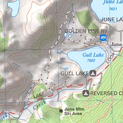
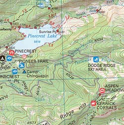
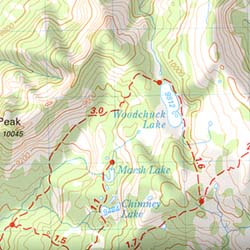
Topographical maps feature the terrain of a wilderness or hiking area, through colored shading & thin contour lines to represent elevations. Park boundaries, trail routes, trail heads & campgrounds are noted, as well as major landmarks like lakes, rivers, creeks, meadows, peaks, canyons, hot springs, waterfalls & all roads (dirt or paved).
Backpackers & hikers must rely on such maps for planning & trekking their journey. Hard copy, printed, waterproof maps are top choice, but topo maps now come in digital format for download as well. DanaMite has recently started including these digital map links within the Total Escape Map Shop – totalescape.net/shop/
Here in California we are lucky to have so much public land available to us for enjoyment. Numerous map vendors make maps for nearly all of the regions across California.

QUADS: 7.5 minute topographic quadrangle maps, available from the USGS, can be found online w/ Avenza Maps (often for free) and also, direct from the government site https://www.usgs.gov/products/maps/topo-maps
A while back, the NFS offered handy books of these sought-after topo maps. They were compiled into booklet form called an ATLAS, with sturdy covers & a spiral bound. Overall size is close to 9″x12″ & they are much easier to handle than the individual paper maps. Look for Forest Topo Atlases
List of topo maps available for California:
- California Wilderness Maps
- Pacific Crest Trail Maps
- NatGeo Topo Trail Maps
- Tom Harrison Topo Maps
- Wilderness Press Maps
 |
 |

