Tag Archives: Backpacking

Sespe Wilderness

Sespe Wilderness & Hiking Trails

Los Padres National Forest
Campgrounds & Trailheads

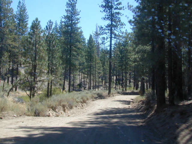
Sespe Wilderness is located in the mountains W of Interstate 5, North of Los Angeles. The chaparral region lies in between Lockwood Valley and the Santa Clara River Valley (Hwy 126). Higher elevation Mount Pinos lies to north side of Sespe and Ojai Valley to the south. The infamous 4×4 Miller Jeep Trail is located on the north side near Alamo Mountain, which is also accessible via Hungry Valley.

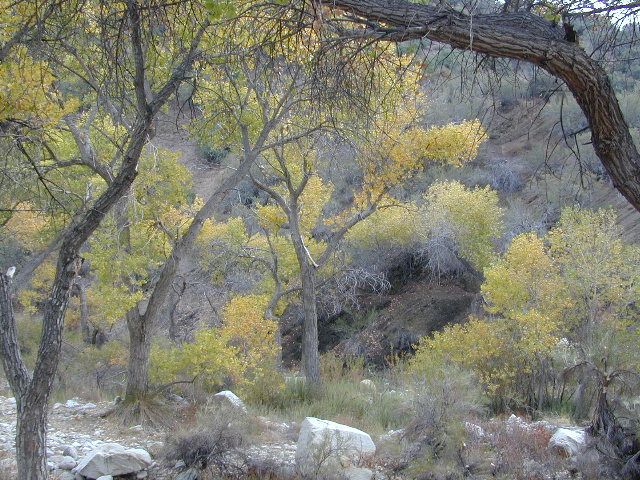
The 2006 Day Fire burnt a good portion of the Sespe Wilderness, so you can expect to see some black and toasted areas. Sespe Creek is also referred to as Sespe River. and certain waterways may dry up during drier months. Piru Creek, Alder Creek, Aqua Blanca Creek, Tarr Creek, Mutau Creek, Snowy Creek are several worthy of note. Expect heat and high temperature in the summer & fall month, and possible campfire restrictions during extreme wildfire season.

219,700 acres
6 areas of hiking trails

Los Padres National Forest
Lockwood Ranger Station
661-245-3731

Sespe Trail Map
Sespe Trails, Tom Harrison Topographic Map

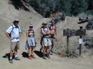
Sespe hiking trailheads located at –

Highway 126 – Fillmore, CA
Sespe Condor Sanctuary – Dough Flat Trailhead

Highway 150 – Ojai, CA
Sisar Canyon Day Hike / Road #4N15

Highway 33 – Ojai, CA
Rose Valley Road #6N31, Rose Valley Falls, Day Hike
Piedras Blanca Trailhead for the National Recreation Trail
Pine Mountain Rd # – Reyes Peak Trailhead

Lockwood Valley Road – Frazier Park, CA
Reyes Creek, Camp Shiedeck – Pine Mountain Trailhead
Half Moon Mutau Flat Trailhead, Sespe Hot Springs

Interstate 5 Tejon Pass @ Hungry Valley
Hard Luck Trailhead


rd7N03

Los Padres Campgrounds near Sespe Wilderness

  • Frazier Park Camping
  • Ojai Campgrounds
  • Twin Pines Campground, Road # 18N01
    Alamo Mountain via Hungry Valley OHV
  • Lockwood Creek Campground
  • Half Moon Campground, Lockwood #7N03
  • Thorn Meadows Campground, Lockwood #7N03
  • Dome Springs Campground, Lockwood #8N40
  • Reyes Creek Campground, Lockwood Valley Rd
  • Pine Mountain Road @ Reyes Peak (dispersed)
  • Nettle Springs Campground, Cuyama Hwy 33
  • Ozena Campground (closed)letswalk
  • Tinta Campground, Hwy 33
  • Rancho Nuevo Camp, Hwy 33
  • Rose Valley Campground, Hwy 33
  • Wheeler Gorge Campground, Hwy 33


nearby parks & lakes –

nearby towns –

Backpackers at Sespe Hot Springs

Dome Land Wilderness

Southern Sierra Nevada Mountain / Domeland / Dome Lands
Kern Plateau, Sequoia National Forest

Dome Land Wilderness

130,081 acres

55 miles of trails (hiking & horseback)

Located at the southern end of the Kern Plateau about 20 miles east of Kernville, granite domes give this area its name. Domeland Wilderness is a unique geologic area with semi-arid to arid mountainous regions. Elevations ranging from 3,000′ to 9,730′ – it is surrounded by National Forest, where the Sierra mountains meet the North Mojave Desert. The Wilderness is the southernmost habitat for the Golden Trout. The South Fork of the Kern and tributary streams attract many fishermen. Vegetation is mostly mixed conifer and piñon (pinyon pine).

The Domeland Wilderness is located at the southern end of the Kern Plateau. This land was first protected by the Wilderness Act of 1964 as a 62,695 acre wilderness and was later expanded to 130,081 acres in 1984 to include the delicate transition ecosystems that meet to the east, south, and north of the original wilderness. These new additions, now jointly managed by the Bureau of Land Management and Sequoia National Forest, are rugged and dry.

Though it is considered within the Sierra range, the Domeland Wilderness includes the overlap of several ecosystems to form unique plant and animal communities. The banks of the South Fork of the Kern River offer important riparian habitats of cottonwoods and meadows which stand in sharp contrast against the characteristic smooth domes and bold granite outcroppings. Domes that range from the size of a cottage to football fields across and spear-like jagged spires can be found in the Domeland. This range is one of the driest in the Sierra with the semi-arid mountains of the north and east crumbling into desert.

Notable Wildfires: Dome Fire 1996. Manter Fire in 2000.

Dome Land trailhead locations:

East side access near Rockhouse Meadow and at the Long Valley Campground (BLM). Access is via Nine Mile Canyon Road (J41) from US Highway 395 or Chimney Peak Road (graded dirt road) via State Highway 178 , the main route that passes Lake Isabella.

West side trailheads are at Big Meadow and Taylor Meadow. Two trails from Big Meadow can be reached from Kernville via Tulare County Road M99, Sherman Pass, and Cherry Hill Roads. Leading to Manter Meadow, the upper Big Meadow Trail is a rugged hike while the lower Big Meadow Trail follows more gentle terrain. The trail from Taylor Meadow (southeast of Big Meadow) also leads to Manter Meadow. North side access is available from the Blackrock/ Sherman Pass Road via the Dark Canyon and Woodpecker trails.

dome land mapManter Meadow is popular along with other camp sites located at Little Manter Meadow, Woodpecker Meadow, Rockhouse Meadow, and in the Bartolas Country at the south end of the Wilderness.

Dome Land Wilderness Map USDA


surrounding lands & forests –

Sequoia National Forest
Ridgecrest Desert BLM

nearby towns –

National Forest & Wilderness Permits –

USDA Sequoia NF

More Dome Land Wilderness Info & Links –

sierrawild.gov/wilderness/domeland
summitpost.org/domeland-wilderness
Dome Land Wiki

Golden Trout Wilderness

Golden Trout Wilderness Area

granite Upper Kern River is Mount Whitney snow melt
  • 303,511 acres
  • elevation range 1,000′ – ­13,000′
  • pine forest, chaparral
  • granite walls, domes
  • 379 miles of trail
  • summers are busy
  • snow in winter
  • best in early spring
  • wood fires may be restricted
  • portable stoves permitted
  • water plentiful
  • rock climbing & mountaineering
  • fishing
  • backpacking
  • primitive hot springs
  • waterfalls, swimming holes
  • wilderness permits required for overnight
Golden Trout Wilderness surrounds the mighty gorge of the Upper Kern Canyon, south of Mount Whitney.
Inside

TULARE COUNTY

bordering

Inyo National Forest

Sequoia National Forest

Eastern Sierra Interagency Center
760-876-6200

Golden Trout / South Sierra Wilderness Map USDA

Golden Trout Trail Map

Located in the South Sierra Nevada mountains alongside the Southern Sierra Wilderness. Inside the remote rugged peaks of a deep, granite crevasse known as the Upper Kern River with ancient Sequoia forest to the west and to the eats, some of the tallest peaks in the Sierra range. This wild land area is home to the California golden trout and is the main water flow southward from the tallest peak in the lower 48  – Mount Whitney on the Eastern Sierra front.

Sequoia National Forest
Monache Meadows
Inyo National Forest
Mountain Home State Forest
Sequoia National Park
Mineral King

Golden Trout Wilderness

Roads, campgrounds and trailheads surrounding Golden Trout Wilderness

Eastern Sierra –

Horseshoe Meadows Road (paved) leads up to high elevation meadows from the high deserts of Lone Pine, CA. Pacific Crest Trail (PCT) access; Mount Whitney and John Muir Wilderness are to the north. Equestrian corrals and horse trails. Camping is limited to a one night stay at any of the 3 campgrounds up here.

Golden Trout Trailhead Campground: elevation 10,000′ / 12 walk-in sites / closed winter
Horseshoe Meadows Campground: elevation 10,000′ / 18 walk-in sites / closed winter
Cottonwood Equestrian Camp: elevation 10,000′ / 10 horse corrals / closed winter

Forks of  the Kern –

Fork of the Kern / Loyds Meadow Road #22S82 – This main paved road connects the Kern River (Sierra Hwy Road #99) to the lower elevation, granite slopes of the Western Divide, and the route dead ends at Jerky Meadow parking lot. Camp 1-6 are primitive camp areas located on dirt side roads and 4×4 might be required on some of them. Obtain a campfire permit from rangers in Kernville. Fishing, camping, waterfalls and swimming holes are popular in this region. The big developed camp along this road, is located 10 miles up, in a pine filled valley on Peppermint Creek on the west side of the street and is within the Giant Sequoia National Monument.

Lower Peppermint Campground: elevation 5300′ / 17 camp sites / open year round

Lloyd Meadows @ Sequoia Forest Road# 20S67 – is the Forks of the Kern Trailhead & the dirt road that accesses it, is very popular among equestrian campers.

Western Divide Highway –

Road #20S79 leads from Western Divide Hwy to Lewis trailhead.
Road #20S50 leads from Western Divide Hwy to 2 hiking trailheads.

Sequoia National Park, Three Rivers, CA –topo maps

South Fork Road leads up Kaweah River at Southfork trailhead.
Mineral King Road is only open seasonally, access to high country lakes and trailheads.


SEQUOIA AREA MAPS –

Golden Trout Wilderness Maps
Sequoia National Forest Map USDA
Inyo National Forest Map USDA
Mineral King Map
Sequoia & Kings Canyon NP Map
NatGeo Sequoia Kings Map

Golden Trout Wilderness trailheads:

east side –
Cottonwood Trailhead (near Lone Pine)
Blackrock Trailhead (Monache Mdws)

south side –
Jerky Trailhead
Forks of the Kern Trailhead
Lewis Camp Trailhead (Western Divide)
Summit Trailhead (Western Divide)
Clicks Creek Trailhead (Western Divide)
Camp Wishon Trailhead (Western Divide)

west side –
South Fork Trailhead (Three Rivers)
Atwell Mill Trailhead (Silver City)
Franklin Pass Trailhead (Mineral King)

List of nearby towns:

Desolation Wilderness

Desolation Wilderness Area

63,690 acres, a federally protected wilderness area located along the crest of the Sierra Nevada mountain range – in between Lake Tahoe and the Gold Country, on the western slopes. This is back country Tahoe @ tree-line, where big, bare granite rock of the High Sierra meets the snow melt in 80 alpine lakes; several streams; hiking, fishing horseback riding, and backpacking. Elevation range approx. 6000′ – 9,985′

El Dorado National Forest

916-573-2600

The Tahoe Rim Trail and Pacific Crest Trail pass through the wilderness.

Desolation Wilderness Map
(National Forest Service USDA)

Desolation Wilderness Topo Map
Desolation Trail Map
(Tom Harrison Maps)

List of Desolation Wilderness trailheads:

  • Loon Lake Trailhead
  • Buck Island Trailhead
  • Van Vleck Trailhead
  • Rockbound Trailhead
  • Twin Lakes Trailhead
  • Lyons Trailhead
  • Twin Bridges Trailhead
  • Ralston Trailhead
  • Echo Trailhead
  • Echo Lakes Trailhead
  • Glen Alpine Trailhead
  • Mount Tallac Trailhead
  • Bayview Trailhead
  • Eagle Falls Trailhead
  • Meeks Bay Trailhead
  • Horsetail Falls Trailhead

List of nearby towns:


View Larger Map

Agua Tibia Wilderness

Agua Tibia Wilderness Area

  • 15,900 acres
  • chaparral & oak at lower elevations
  • pine & fir forest at high elevations
  • elevations range 1,700′ – ­5,000′
  • 25 miles of trail
  • summer temperatures exceed 100°F
  • occasional snow in winter
  • best in winter through spring
  • wood fires prohibited
  • portable stoves permitted
  • water scarce
  • no overnight use of pack or saddle stock
  • groups limit – 15 people
  • visitor permits required
Agua Tibia lies right on the RIVERSIDE
& SAN DIEGO COUNTY border

Cleveland National Forest
Palomar Ranger District
1634 Black Canyon Road
Ramona, CA 92065
760-788-0250

Agua Tibia Map

Agua Tibia Trailhead

This is the trailhead for Agua Tibia Wilderness located at Dripping Springs Campground on Highway 79, near Temecula CA.

See more: Agua Tibia Mountain hike details

hiking SoCal

San Mateo Canyon Wilderness

San Mateo Canyon Wilderness

  • 9,700 acres, South of Highway 74
  • hiking near Temecula, California
  • between Camp Pendleton & Lake Elsinore
  • moderate to steep terrain
  • vegetation chaparral on slopes
  • riparian vegetation in stream channels
  • oak woodland at lower elevations
  • accessible by several routes off Hwy 74
  • accessible by dirt roads
  • some access routes may be closed in wet weather
  • best times to visit are spring & fall
  • wood fires prohibited
  • portable stoves permitted
  • visitor permit required
Cleveland National Forest
Trabuco Ranger District
1147 East Sixth Street
Corona, CA 91719
714-736-1811
San Mateo Wilderness Map

Pine Creek Wilderness

Pine Creek Wilderness Area
East of San Diego, California

  • 13,400 acres
  • gently sloping area
  • elevations range – 2,000′ ­ 4,000′
  • vegetation is chaparral & scrub
    oak
  • riparian & woodland vegetation in stream
    bottoms
  • Pine Creek & drain the area north to
    south
  • rainbow trout in Pine Creek
  • streams are dry for parts of the year
  • several trails provide access to area
  • wood fires prohibited
  • portable stoves permitted
  • groups limit – 15 people
  • visitor permit required
Cleveland National Forest
Descanso Ranger District
3348 Alpine Boulevard
Alpine, CA 91901
619-445-6235

Pine Creek Wilderness Map

San Diego Mountains

San Diego Mountain / Hiking San Diego / SoCal Camping

hiking San Diego

San Diego forests & parks – 

Cleveland National Forest

Palomar Mountain State Park

Anza Borrego Desert State Park

San Diego maps & trails –

San Diego mountain towns nearby Alpine, Descanso, Julian, Mount Laguna, Palomar, Ramona

mt laguna lodge