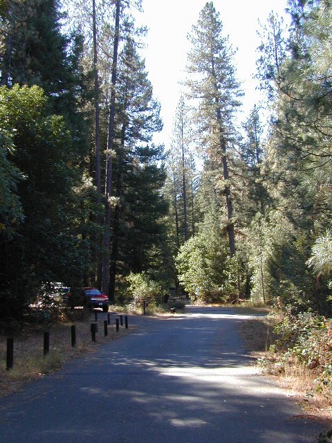
NorCal – Klamath River: 2017 fire season provided significant firefighting challenges. In order to meet future challenges in the most effective way possible, the NFS will continue to use prescribed burning as a tool in our mission to reduce build-up of hazardous fuels, restore forest ecosystems, and improve resiliency and safety of communities within the wild-land urban interface.
Planned projects include burning piles of stacked materials and low to moderate intensity understory burns of vegetation on the forest floor. The main goals of these projects are to reduce the severity of future wildfires and provide added protection for communities in the wild-land urban interface. In addition, the burns will promote a diverse and more resilient forest, and improve habitat for wildlife.
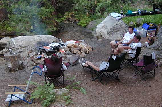
NorCal River Camping, Fishing, Kayaking, Rafting, Recreation.
Klamath burns will take place on the Salmon River, Scott River, Happy Camp, Oak Knoll and Goosenest Ranger Districts between April and June 2018. The actual dates of ignition will depend on local weather and fuel conditions.
Northern California is the top third of the golden state, the area north of the San Francisco Bay Area and north of the Napa wine country. North of the Sierra Nevada mountains, North of Lake Tahoe. The waters we focus on here are in and around Klamath National Forest
Lakes, rivers, creeks, waterfalls, waterfowl, fishing and fresh water are all plentiful in the Klamath region. Mount Shasta and the Klamath mountain range make up a portion of the Cascade range, that continue north to the Pacific Northwest. Klamath Falls and Klamath River originate up in Oregon, but the list below features the California regional lakes.
The dam projects of the Klamath River have always been a controversial subject for many local activists. The Klamath River Keeper web site currently warns us –
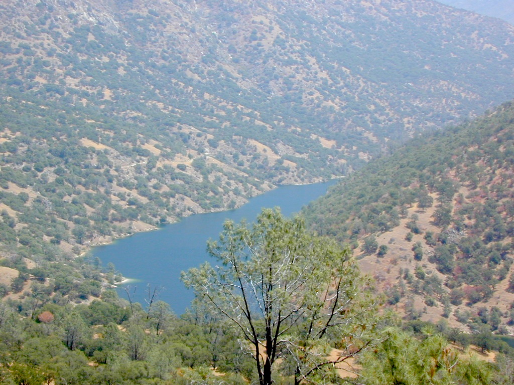
Officially this lake is actually a reservoir, located in the low lands of the Sierra foothills country. Narrow, winding back roads, a way outta the way kinda spot.
a long, narrow lake w/ steep hills, inside a tight canyon
canoe
fishing
hiking
jetski
kayak
waterski
The San Joaquin River flows west, down from the highest granite peaks of the Sierra Nevada and into the Central Valley foothills. If you find your way off the main highway 41, exploring way back behind Bass Lake, CA – then you may consider this scenic loop to Redinger.
off the beaten path
Truthfully, this place is usually an afterthought, sorta near Yosemite National Park. Not exactly a top destination for tourists, but it is very accessible most anytime of the year due to low elevation.
Spring wildflowers can be decent.Summers do get super hot here, so take that into consideration when planning your visit. Due to extreme wildfire danger, no campfires are allowed at any time.
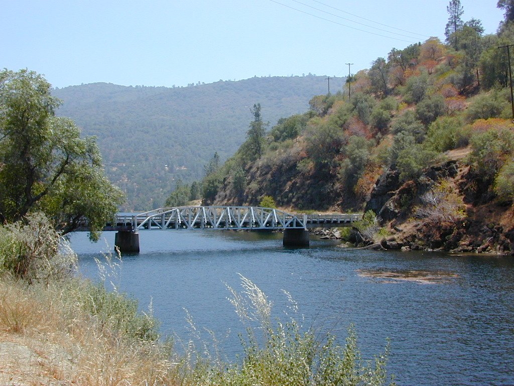
Lake, Reservoir, or a good wide section of the San Joaquin River w/ hydro-electric dam.
elev. 1000′
public boat launch ramp
Camping is restricted to a large open area near the dam. No fee is charged. No campfires are permitted. Services limited, no drinking water or garbage pick-up available. Nearest town 7 miles away.
Redinger Lake Road (Rd# 235) can be found south of the town of North Fork, CA. The paved route down is long, steep and winding. At the bridge crossing, the road loops to Joe Basin Road, which connects to the small community of Auberry, CA
Way up river, a dozen plus miles, is the utterly beautiful Mammoth Pool, only accessible half the year.
A few miles down river from Redinger, around the horse shoe bend, another neighboring reservoir called Kerschoff Lake (elev 971′) has a developed campground.
Mojave Reservoir @ Colorado River: AZ / NV / CA
@ the V, bottom of Nevada state = Arizona – Nevada – California, all merge together
The Colorado River travels through the southwest desert, splitting the Grand Canyon and further south, separating California from Arizona at the southern tip of Nevada. Agriculture lines the big river down to Baja, Sea of Cortez, Mexico.
Up near Las Vegas and down to Searchlight, NV
Above Hoover Dam is Lake Mead, sediment from Utah National Parks. Red dirt and silt shorelines. South of Hoover dam is a super deep rock gorge w/ hike-in hot springs. Beyond that, this beauty called Lake Mohave – with the super clear water, secluded coves and abundant fishing.
Lake Mohave: elevation 647′
Desert peaks in this region are around 2000-3000′ elevation. Mohave Lake is actually a wide section of the Colorado River, spanning the region from massive Black Canyon south to busy Laughlin w/ river casinos. This lake is long and skinny in spots with lots of shoreline cliffs, canyons and coves. Minimal vegetation, so please bring your own firewood and don’t chop down the few trees trying to survive. Summer temps exceed 100 degrees, so plan your visit for the winter time.
Lake Mohave Ranger Stations
Cottonwood Cove
Katherine Landing
boating, camping, fishing, hiking, hot springs, kayaking, off-road, picnics, viewpoints
El Dorado Canyon Road, main paved route can be accessed near California’s state border. North of Searchlight, Nevada – off main highway 95, on side route 165 to Nelson, NV
Secluded dirt roads up and down canyons near El Dorado Canyon Rd. Minimal vegetation, maximum open scenery and dark skies. Kayak rentals @ El Dorado Canyon.
desert badlands erosion
Ireteba Peaks Wilderness
4×4 camping routes: 15 day camping limit
Find your own route with many to choose from, drive the soft sandy washes (with a few boulders to dodge) and camp for free, right at the waters edge. Adventurers: Only for the self-contained campers. Some routes marked 4WD only, so pay attention to signs. AWD (all wheel drive) vehicles should fare well on the sandy roads; but standard passenger cars and vans will need to keep their speed up in the soft sand areas.
No garbage collection. Pack it in, pack it out.
No facilities, no fees. No buildings. No campfire rings, no picnic tables, very few vault toilets. Bring your shovel!
Driving off the roads is strictly prohibited. Primitive camp sites can be found both at numerous coves and also inland inside the canyons. The ridges get windy in the deserts, but are favorable for night sky views and self contained camper vans.
Always know the weather forecast, cuz flash floods are possible and these dirt roads will be impassible during big rain. This is the main drainage to the big river!
DRIVING TIPS
Most desert washes here are signed routes 4×4, but mini vans, AWD sport-wagons, trucks, SUVs, small RVs can all be found camping near Lake Mohave. That is – if you know how to ‘drive off road’, which is not fast, but not too slow either.
Avoid getting stuck in the deep sand: keep speed up, do not turn sharply and do not brake hard. Carry tow strap in case you need an emergency pull. Be nice to strangers and you may find help.
Campfires are allowed, but you need to bring firewood. Dogs are allowed. Party animals tend to trash these desert coves, so be warned that there is a fair amount of litter. Bring a black trash bag and take some out! This trash problem could get the area closed off to vehicles so keep that in mind.
The canyons here have giant power lines that cross @ Aztec Wash; they can easily be avoided.
4×4 recommended @ MOHAVE:
Eagle Wash Road #46 – popular spot
Montana Wash #45 – camping ok
Placer Wash #47 – no camping
The rangers don’t wanna be pulling your ass out of the sand, which is why they post the 4×4 signs. Don’t expect to find help without walking a few miles first, or waiting several hours.
desert wilderness
Several wilderness areas are located along the west side of this lake & river. Often dirt roads will parallel a portion of the wilderness boundary, providing excellent access to secluded coves and beaches. Emergency CALL boxes are placed in remote parts of these shores.
Ireteba Peaks Wilderness (northwest, next to El Dorado Canyon)
Nellis Wash Wilderness (western side)
Spirit Mountain Wilderness (southwest)
Bridge Canyon Wilderness (southwest, near Laughlin)
COTTONWOOD COVE
developed campground, boat launch, marina, lodging, hiking, picnic areas
LAUGHLIN, NV
Nevada, California and Arizona states join down in this part of the world. Katherine Landing, full service marina, slip rentals, lodging, city services and casinos.
Mojave Desert – This river-created lake is located on the Colorado River, in between Las Vegas, Nevada and Needles, California. The river water here is crystal clear, very swimmable and the fishing is decent. No paved boat ramps
nearby towns: (with elevation)
Avi Casino
Bullhead City, AZ (540′)
Laughlin, NV (535′)
Kingman, AZ (3340′)
Needles, CA
Nelson, NV (2954′) Nipton, CA (3042′) Oatman, AZ
Searchlight, NV (3470′)
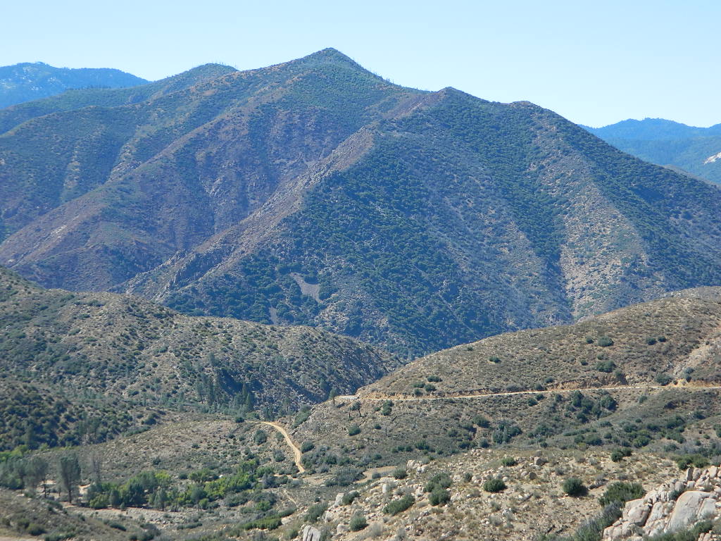
Sequoia National Forest covers a large portion of the Southern Sierra, surrounding the Kern River canyon. This trail list is NOT for off-roading in the Sequoia groves!
The regions here are further south, below the Western Divide & Trail of 100 Giants.
If you are looking for more than a leisurely Sunday drive or a self guided back road tour, listed below are areas to “tear it up” on dirt w/ your motor bikes, machines & off road toys. Camping is common in certain spots.
CAMPS: Please be respectful of other campers and hikers; do not ride circles around camp sites, stir up dust or rev up engines at night. Choose a camp away from main roadways and access trails for a more enjoyable experience. Equestrian campers often use these same areas for meadow camping and horseback riding. A campfire permit is required.
Just looking for some dirt roads to explore – at a more leisurely pace?
Check out DanaMite’s Sequoia Back Roads list, where you can find awesome unpaved roads throughout the Sequoia Forest & Kern Canyon region. Some of these secluded routes lead to great primitive camping sites, waterfalls, fishing holes, or amazing view points, but are not necessarily popular ATV routes.
Bear Meadow: Forest Rd# 23S64 – Packsaddle Creek, Sequoia National Forest
For the more adventurous & ones seeking some seclusion, Bear Meadow is located up the dirt road a bit from Thompson Camp Spring . From Forest Road #23S16 @ Thompson Camp Spring – continue straight on the dirt road #23S64, cross over the one lane wooden bridge; within a mile, turn left into a secluded creek side camping area. Note: Bears are common here (hence the name Bear Meadow)!
Packsaddle Creek runs thru this forest. Very primitive area with rutted dirt roads & sometimes overgrown; there are several campsites back in here for the ones who seek the wild. (Yes, bears & wild animals are very common way back here). If you continue on straight on the main dirt road Packsaddle Meadow also has camping spots & small corral. The last time we were out this way (2002-ish), the dirt road does not connect with highway to the west, as indicated on the map; due to landslide.
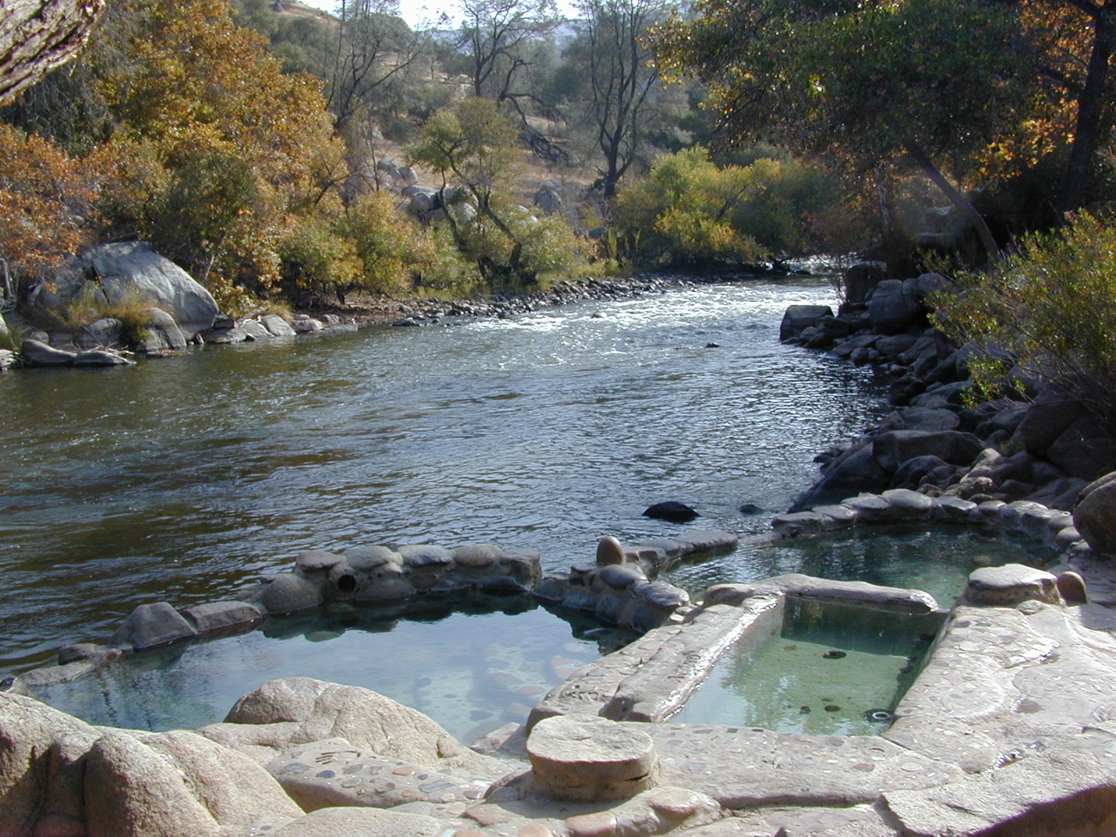
From Lake Isabella down to Bako, along Hwy 178, numerous natural hot springs can be found in this lower Kern river canyon. Old Kern Canyon Road has plenty of primitive spots to camp along the road, way above the Kern River. This Southern Sierra Nevada scenic route, a 20 mi winding narrow paved road, is the old highway that leads up to Bodfish CA.
At least a dozen dispersed camp sites can be found along the Old Kern Cyn Rd, some spots with views over canyon, some hidden & shady, many spots are level & large – suitable for RVs. No facilities, no fees, just a flat, dispersed site. Campfire permits are required for fires outside of developed Campgrounds & fire restrictions are often high, so no fires are allowed much of the year. Most of the gates on the Lower Kern are now locked & only accessible by Forest Service personnel, ranchers or local rafting companies with permits.
2 developed Lower Kern Campgrounds are located on the Old Kern Canyon Road, which parallels the 4 lane portion of the highway: Hobo Campground & Sandy Flat Campgrounds, if you really need a picnic table & bathroom. You can reserve camps by clicking the links.
Miracle Hot Springs – next to Hobo Campground. This hot tub park is closed for good. A few portable bathrooms, picnic tables & trash bins, the hiking trails clear; 2 shallow pools partially filled. Maybe enough room to soak your butt, but not fully submerse yourself. Someone really needs to renovate this place! Update 2012 – the signs for Miracle are now completely gone.
This one is by far the most popular now that Miracle is gone. The hike-in only access doesn’t deter people much and many choose to set camp overnight close by. The local authorities are always making the rounds to double check on the area – which is good for security and bad for the 2 AM party animals.
Democrat Hot Springs
private resort now open? Heck, I dunno. (2017, democrathotsprings.com is down. They might be trying to promote a River Festival held in May.)
The hotel and cottages were constructed to accommodate guests that came in stage coaches to dine and relax during the early 1900’s. Five springs on the property flow at 115 degrees into large soaking tubs and a swimming pool. Closed to the public for more than thirty years, the resort is once again ready to be brought to life for groups and private events only.
The hot springs listed below are Private Property, so don’t get caught – and don’t get shot:
Delonegha Hot Springs
Concrete tubs were built by homesteaders, later a hotel and boarding house were constructed. Stage coaches from the San Joaquin Valley took 2 days to get visitors to this area. The hotel closed in 1912, when more accessible areas of Democrat and Hobo were built. Remaining cement tubs run along a rock peninsula overlooking the Kern River; water temperatures average 112 degrees. This private property is fenced.
Scovern Hot Springs
Also known as the Hot Springs House. 1902 mud baths were being offered and the wooden tubs were replaced by galvanized tubs. A swimming pool and bath houses were added when the Scoverns bought the property in 1929. Bath house burned to the ground in 1971 and only a vacant lot remains. Steam can still be seen in the fields across from the springs, where water runs at 140 gallons a minute @ 115 degrees.
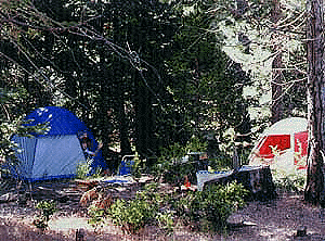
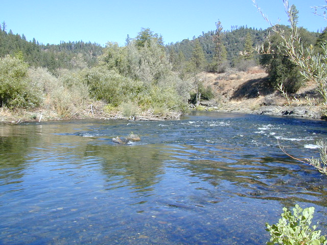
Northern California river camping. Douglas City is hardly even a town much less a city. A post office and a general store is the majority of what makes up this riverfront locale.
Tucked away on the scenic Trinity River, this small campground is perfect for those wanting to explore the Trinity River, Trinity Lake or the Trinity Alps region. Region is well known for fishing, hiking, kayaking and rafting. A small beach allows for river access. Group picnic area, picnic tables, telephone, beach, paved loop road are just a few amenities.
From Douglas City, drive half mile west on Hwy 299 to Steiner Flat Road. Follow signs to the developed camp. Numerous dirt roads lead to river edge, so there are primitive camping options available along Steiner Flat Road for those seeking free overnight stays.
• Elevation: 1,500′
• Number of Sites: 20
• Camping Reservations: No
• Sites Available: First come, First serve
• Vehicle Accessibility: Vehicle limit 28 ft. max.
• Length of Stay: 14 Days
• Water: Piped; river nearby
• Toilet: Flush & Vault
• Season: Closed for winter, Nov-April
• Fee: Yes
• Operated By: Bureau of Land Management
• Closest Town: Douglas City, CA
Located in the South Sierra Nevada mountains alongside the Southern Sierra Wilderness. Inside the remote rugged peaks of a deep, granite crevasse known as the Upper Kern River with ancient Sequoia forest to the west and to the eats, some of the tallest peaks in the Sierra range. This wild land area is home to the California golden trout and is the main water flow southward from the tallest peak in the lower 48 – Mount Whitney on the Eastern Sierra front.
Roads, campgrounds and trailheads surrounding Golden Trout Wilderness
Eastern Sierra –
Horseshoe Meadows Road (paved) leads up to high elevation meadows from the high deserts of Lone Pine, CA. Pacific Crest Trail (PCT) access; Mount Whitney and John Muir Wilderness are to the north. Equestrian corrals and horse trails. Camping is limited to a one night stay at any of the 3 campgrounds up here.
Fork of the Kern / Loyds Meadow Road #22S82 – This main paved road connects the Kern River (Sierra Hwy Road #99) to the lower elevation, granite slopes of the Western Divide, and the route dead ends at Jerky Meadow parking lot. Camp 1-6 are primitive camp areas located on dirt side roads and 4×4 might be required on some of them. Obtain a campfire permit from rangers in Kernville. Fishing, camping, waterfalls and swimming holes are popular in this region. The big developed camp along this road, is located 10 miles up, in a pine filled valley on Peppermint Creek on the west side of the street and is within the Giant Sequoia National Monument.
Lower Peppermint Campground: elevation 5300′ / 17 camp sites / open year round
Lloyd Meadows @ Sequoia Forest Road# 20S67 – is the Forks of the Kern Trailhead & the dirt road that accesses it, is very popular among equestrian campers.
Western Divide Highway –
Road #20S79 leads from Western Divide Hwy to Lewis trailhead.
Road #20S50 leads from Western Divide Hwy to 2 hiking trailheads.
Sequoia National Park, Three Rivers, CA –
South Fork Road leads up Kaweah River at Southfork trailhead.
Mineral King Road is only open seasonally, access to high country lakes and trailheads.
east side –
Cottonwood Trailhead (near Lone Pine)
Blackrock Trailhead (Monache Mdws)
south side –
Jerky Trailhead
Forks of the Kern Trailhead
Lewis Camp Trailhead (Western Divide)
Summit Trailhead (Western Divide)
Clicks Creek Trailhead (Western Divide)
Camp Wishon Trailhead (Western Divide)
west side –
South Fork Trailhead (Three Rivers) Atwell Mill Trailhead (Silver City)
Franklin Pass Trailhead (Mineral King)
MIRACLE HOT SPRINGS on Lower Kern River is now closed!
Hidden well by the dense vegetation, this multi-tub location provides a peaceful setting along the Kern River. Located on the Old Kern Canyon Road, (aka Old Kern Road) that parallels the main 4-laner Highway 178. The broken and dismantled tubs are inside a grouping of granite boulders, overlooking the Lower Kern River. NFS Campground is walking distance away. Week days you can have the place to yourself for picnics, river fishing and hiking. Mountain biking and hiking trails at Remington trailhead.
DanaMite’s Tip: This place has no operating hot pools unless you plan to physically dam up a tub with a few found rocks. Rangers do not like this practice. If you wanna camp at Hobo Campground you can walk over & hike around to check it out. Worth a look.
Camping available next door at Hobo Campground. A few primitive spots are located on the Old Kern Canyon Rd. Free car camping, and some sites big enough for level RV camping. See the rangers at the lake for Sequoia National Forest ranger and fire permit and check fire current restrictions.
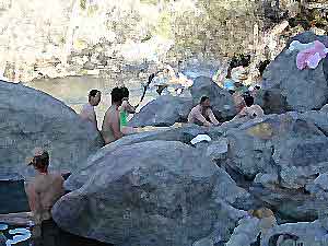
Remington Hot Springs is only 2 miles down river, but it does require a short hike and it gets very busy on weekends!
Colorado River: Tri-State area includes Arizona, California, Nevada. From the northern Lake Mead @ Las Vegas to the lower Colorado River marshes of Yuma, a span of fresh water that travels the western deserts. From the snow melt of the Rocky Mountains, through the red rock of Utah’s canyonlands, Grand Canyon and all it’s glory, way down to the farms near Mexicali, this is the biggest river in the west.
outdoor recreation includes –
fishing, camping, kayaking, canoeing, boating, houseboats, water ski, watercraft rentals
Below are personal water craft rentals and shops around the region.
LAKE MEAD PWC RENTALS
Callville Bay Marina
800-255-5561
Lake Mead Resort Marina
877-765-3745
702-293-1191
Skiwi Rentals
702-568-8999
Temple Bar Marina
800-255-5561
World Wide Jet Ski
702-558-7547
LAKE MOHAVE PWC RENTALS
Cottonwood Cove Marina
800-255-5561
Willow Beach Marina
928-754-2443
BULLHEAD CITY, AZ
AC Watercraft Rental
928-767-4747
River Rats Water Sports
928-754-4782
LAUGHLIN, NV
Avi Resort
800-430-0721
702-535-5526
Best Jetz
702-298-0757
Xtreme Watercraft Rentals
702-298-7541
LAKE HAVASU CITY
All Seasons Water Sports
928-706-2512
Champion Rentals
928-855-8088
Dana’s Rental
928-854-1124
Desert Sun Watersports
928-706-3958
London Bridge Watercraft Tours & Rentals
928-453-8883
Walt’s Motorsports Marine
928-855-5019
Wet Monkey Powersport Rentals
877-938-6659
Windsor Beach Rentals
888-428-2792
928-453-4792
YUMA, AZ
Jet Rent
928-314-4345
Jet Ski is a registered trademark under Kawasaki
Watercraft manufacturers also include: Sea-Doo & Yamaha

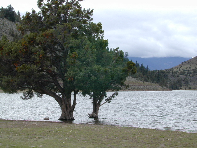
 Lakes, rivers, creeks, waterfalls, waterfowl, fishing and fresh water are all plentiful in the Klamath region. Mount Shasta and the Klamath mountain range make up a portion of the Cascade range, that continue north to the Pacific Northwest.


 Lake Mohave Ranger Stations


 Mojave Lake