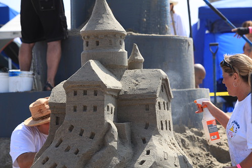
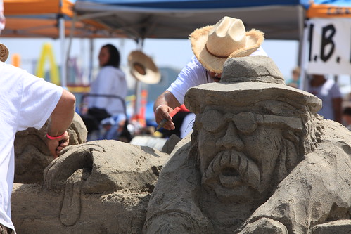
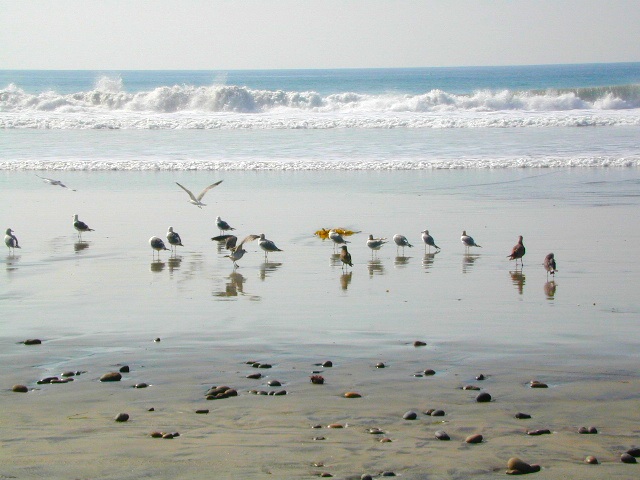
IB Sun and Sea Festival
San Diego county’s Imperial Beach is the home of the biggest & best sand castles on the west coast. Sandcastle City!
Annual event; August
sunandseafestival.com

San Diego county’s Imperial Beach is the home of the biggest & best sand castles on the west coast. Sandcastle City!
Annual event; August
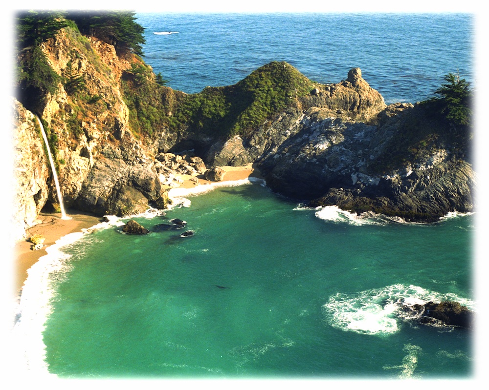
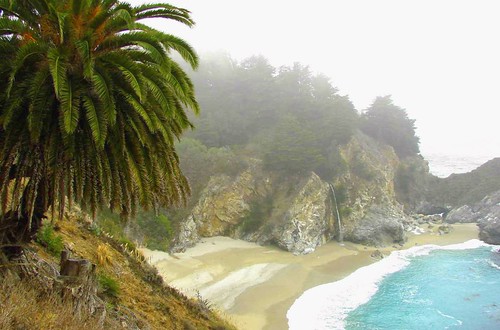
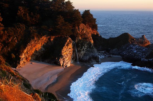
The super scenic Central Coast of California is home to numerous waterfalls, but this one on the Big Sur coast is, by far, the most well-known.
Since I camped out and slept on the cliff featured above, I thought I ought to create a post about it.
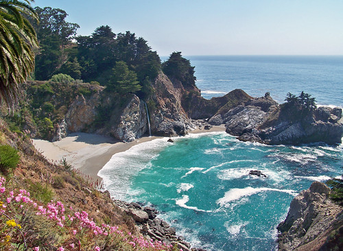
Julia Pfieffer Burns State Park is where the most photographed waterfall is located. The creek falls off of a cliff into a secluded cove, on a sandy beach just a few feet from the Pacific Ocean.
After visiting this place more than once, I knew I had to keep coming back. I even found this waterfall photo used as graphic marketing for Mexican Riveria cruises, by Costco.

One sunny autumn day, I called my camping pals to join me on our pre-planned camping trip to the majestic Big Sur coastline. Not just any camping spot or campground, but the two rare, hike-in campsites – located above McWay Falls. The camp reservations had been made months in advance and I was eager to leave the smog basin of L.A.
One by one, all my friends backed out of their commitment to camp that weekend. Too busy at work, a wedding or other plans interfered, home improvements, or the typical lame excuses that city folks always use not to travel locally.
…only 2 camp sites exist here, perched on a forested cliff, overlooking a private sandy cove w/ a gorgeous waterfall
I thoroughly explained to them the spectacular scenery, the unique location, the advanced reservations and fees, and the carpooling options. But not one person could go, so I went anyway.
All alone; which may have been the start of me craving to camp solo (way back in 1995).
The California State Park system has named these as environmental camps, where you must haul your gear – a half mile, on foot, in order to reach these special campsites. Picnic tables and campfire rings are provided, along w/ one vault toilet. Although a real bathroom w/ flush toilets is within walking distance, over at the main paved parking lot.

INACCESSIBLE:
The picturesque sandy cove is off limits to all = campers, hikers and climbers. New fencing and signs warn visitors not to enter the small beach cove area. Sheer, steep cliffs w/ erosion are unstable and dangerous; and you may have a citation awaiting you, on your climb back up.
Accessing the cliff edges or private cove is dangerous and difficult, and totally off limits. If you wanna die trying, that’s up to you.
OVERNIGHT TIPS:
Reservations are needed to camp at this location. Contact California State Parks for booking this spot.
The ocean sounds of crashing waves on rocks is very, very loud. located just below (100 feet) the ideal camp sites. Bring ear plugs for sleeping.
Leave food and cooking to the tailgate. Parking in the paved, forested parking lot, and not transporting food, ice chest and cookware back and forth is the lazy way. Since I was camping alone and the parking lot was secluded and full of vegetation, I decided to try minimal food at camp. Worked well for me.
Blackberry bushes are abundant around parking lot.
PANCAKES ANYONE?
Danger looms around this State Park entrance, as Coast Highway 1 drivers tend to speed by at 55 mph, on a big shady curve. Be very careful crossing the road at this location and listen for traffic before you walk.

TRAILS & DAY VISITORS:
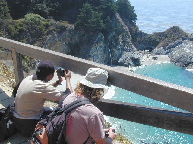
Swarms of tourists stop at this location, just to walk out, photograph and view this waterfall. Many pay top dollar (day use) to park and then stay less than an hour. The tunnel trail goes past a pelton wheel and then underneath the highway – skirting along the north shore of the cove. The State Park gate closes at sunset, so very few people will be found roaming around after sundown.
Just hiking around this park, plus the back and forth to camp and car will feel like you’ve walked many miles. There is a redwood canyon and creek hike located in the inland portion of the State Park. Mountain peaks here reach to about 3000′ elevation.
AUG 2020 UPDATE: WILDFIRES burning most of this State Park and Limekiln State Park. Not sure how the cove looks now, or if it was affected, but expect the hills to be black, up above the highway.
![]() 52801 CA State Route 1, Big Sur, CA 93920
52801 CA State Route 1, Big Sur, CA 93920
831-667-1112
If there is a single most popular image of Big Sur, it is probably of the 80 foot falls seen from this trail as McWay Creek cascades onto the sandy shore. hikinginbigsur.com/hikes_mcwayfalls.html

Even though I spent the warm weekend alone, camping on a waterfall cliff and hiking redwoods forests, I enjoyed myself and the seclusion. I did meet 2 surfers traveling in a vintage VW bus and they joined me for my tailgate dinner one evening. On the last night, the weather turned windy and a storm came in, so the next morning I was happy to leave. So, for all the camping pals that backed out at the last minute, this 2020 post is for you.

Canon Sin Nombre – Anza Borrego
Mud Caves and Slot Canyon Hikes
 Desert Slot Canyons – South Anza Borrego State Park region, just off County Road S-2 east of the ‘badlands overlook’ view point is a whole network of narrow walkways & skinny canyon trails to explore. Some are so tight you have to turn side ways to fit through. There are more than one of these sandstone topless caverns. Finding a new one each time you visit is a fun challenge. Just north in the Diablo canyon there are dry mud tunnels & trails as well. Explore & be careful not to get lost. And don’t camp at the canyon openings during the threat of heavy rains…duh.
Drive down steep, sandy road into Canon Sin Nombre entrance (the dirt road just to the north of Badlands Overlook). A high clearance vehicle is recommended and 4WD may be required in soft sand. 2WD SUVs/trucks should keep their speed up through the soft sandy areas & try not to turn or stop suddenly. Go slow in narrow sections of the canyon & slow over the rocks to save your oil pan.![]()
Clock your mileage 1 mile exactly from the paved road (s2) & park out in desert wash, pull over between the smoke trees. Hike over to the left side & look for an opening in the canyon walls to a deep secluded trench. A campsite may exists here.
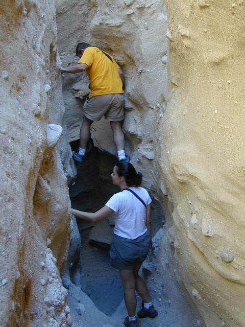
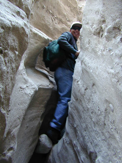
Hike up the first canyon which does require some rock scrambling. The gorge lets you out at the very top with an impressive view over the Sweeney Pass area. The canyon walls are so tight in some spots you may have to turn sideways to fit through. Upper body strength is needed to climb high ledges & boulder scramble through this natural maze.
Once on top, wander on the ridge & check out the views; keeping to the right & then follow the next wash down to start the much longer & easier exit. Hike down in the main slot canyon which leads out to a big camp site & clearing. Exit slot area and turn right, walking back to the vehicle in the big wash.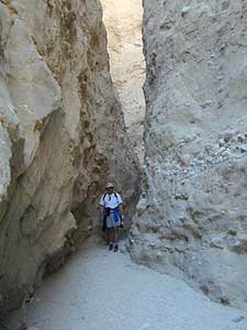
This particular hike is a blast on a full moon night, but not for a first timers try.
Best time to visit: October – April
HIGH CLEARANCE VEHICLE access to reach trailhead. Moderate hike, boulder scrambling w/ dangerous mud walls. Flash floods here are possible during rains.
Plenty of 4×4 roads, SUV trails, & box canyons in the desert region.
Open primitive camping (free) all over
Anza Borrego State Park
The 2 nearest developed campgrounds:
Bow Willow Campground
Vallecito County Park
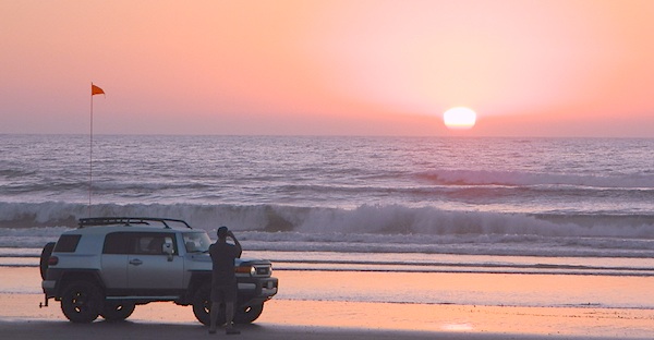
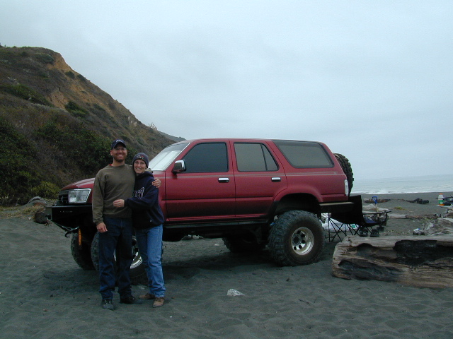
Gone are the days of ‘beach blanket bingo’ where film crews glamorized California – the beautiful people, the nice vehicles, the sport of surfing and the glorious beaches. There are very few places left on the California coast that you can actually drive a vehicle on the sand, right next to the ocean. The military bases, oil corporations and the utility companies have the front row seats to the Pacific genocide, and the rest of the population is restricted with extreme limited access.
Baja California has minimal regulations on coastal access with a car. No pavement, no signs, no cell phone signal, and no help for miles – something to consider if you get stuck south of the border in Mexico. Baja has numerous places to explore below Ensenada, but asking locals is always a favored approach. Pay attention to private property signs and always close the cattle gate (if you found it closed).
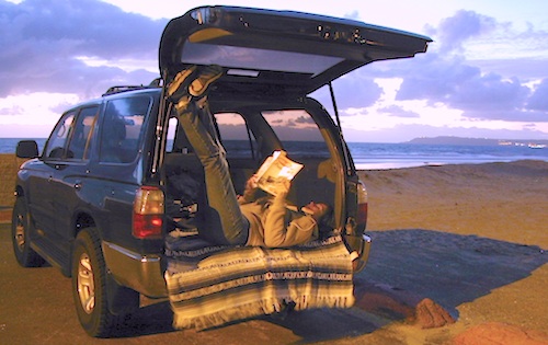
Southern California, no beaches allow vehicle traffic. San Diego offers a sliver of sand @ Silver Strand SB, which is a developed campground for motorhomes and car campers, located right on the beach south of Coronado, CA. Fiesta Island in Mission Bay, San Diego allows driving on sand and a favorite among active dogs, but not camping is allowed. In Los Angeles you can park a motorhome at a sandy, paved campground for a hefty overnight fee. Dockweiler Beach, right near the Chevron plant and LA sewage treatment facility. Sounds delightful, not.
Ventura & Santa Barbara Coastal Regions have many awesome State Beaches, but none allow vehicles on the sand.

Central Coast California:
Northern California:
Lost Coast
after-the-fun maintenance tip:
Salt water and sand is very corrosive to metal – which will rust your truck or car badly. Now that you’ve had fun on the beach, we remind you to clean the underneath of your vehicle ASAP. Spraying powerful hose in your wheel wells and all underneath the vehicle. You might need to lay on the ground and get wet to do this job properly. Some car wash places might be able to do this service for you, but it will cost ya.

![]()
![]()
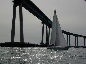
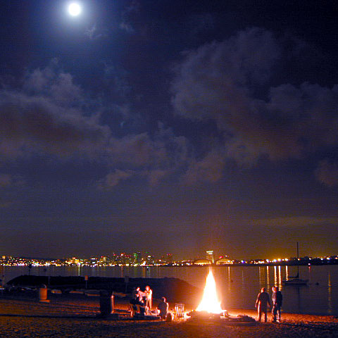
San Diego’s mild climate means camping is available all year round. Winter storms can get windy and rainy, but most campgrounds are still open. From north county where the coastal cliffs overlook the ocean, to downtown bay side marinas w/ RV camping, to camping right on the sand w/ ocean crashing just feet away. Bike paths are common around downtown San Diego, so you can bring your bike or skates.
San Diego has 2 BAYS, both located along Interstate 5: The main bay downtown is called San Diego Bay (one of the deepest on the west coast) and the other a few miles north, is named Mission Bay (a man-made coastal waterway w/ green parks and paved bike trails).
Reservations are required at almost ALL coastal campgrounds, especially around holidays, any 3 day weekends, and all summer long. Tons of tourists flock to Southern California and this is a very popular coastline – with busy little cities and crowded beach towns. Beware: if you are seeking secluded camping – this would not be the place.
listed from south to north
There are numerous private RV resorts, some quite large, like KOA and GoodSam parks located in and around San Diego county. Most are metro-close and not located on the beach. This list is primarily coastal camping options for the San Diego region.

Being the largest State Park inside California, Anza Borrego has certain advantages. Lots of land to explore, abundant dirt roads, free camping and a very diverse terrain. Located in SoCal, this desert has lots to offer the outdoor enthusiasts, all year round.
with hundreds of miles of dirt roads to explore
The Anza Borrego desert, in east San Diego County, is quite large and very easily accessible from Southern California. The park spans mid-elevation, mountain foothills (3000′ elevation) down to dry lake beds near sea level. Large, vast and varied terrain – and full of vegetation in certain spots. Borrego Desert Wildflower blooms attract thousands of visitors between March-May each Spring.


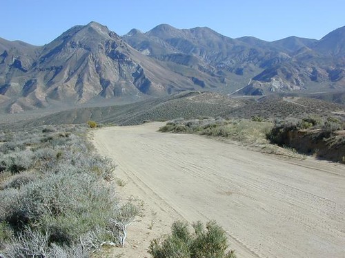
While the majority of the dirt roads inside the ANZA DESERT are passable with a regular passenger car (on most days), some specific areas and routes are indeed considered “too hairy” and may require a 4 wheel drive. Rains change landscape fast in this region, so know before you go.
FLASH FOOD WARNING: Wet weather (anywhere nearby) can make a mild, soft, sandy wash into a wild, flowing river. On occasion desert washes are ‘washed out’ during big rain, often becoming mini rivers that can swallow your vehicle; Road and weather conditions can change suddenly in the California deserts. Wind can also play a huge factor in a selecting a decent camp site. Know the weather report in advance and always be on the watch for big clouds on mountains to the west.
Deep sand washes, steep sandy hillsides, boulder passes, rock yards to boulder hopping, soggy bottoms to straddling ruts, the deserts of SoCal are indeed fun and challenging. Enjoy your public lands responsibly and pick up some litter, stay on the trail and do not target shoot inside park boundaries.
To find these off-roading areas: OHV routes, camp areas and gear heads galore. Or try avoid them. Keep reading.
the well known spots
Anza Borrego Desert State Park itself is NOT AN OFF ROAD PARK. If you want the free-for-all, open, OFF-ROAD areas, with sand dunes and terrain to explore, then the list above should help. Some places can be secluded and private for camping, and only one Jeep may pass by (for the whole weekend).
On the other end of the spectrum, most OHV camping areas are closer to paved routes and busy w/ motorized activity. On weekends, traffic, events and crowds are the norm. ATV, dirt bikes, buggies, quads, jeeps, families, RVs. Often, a big noisy scene.
Seeking to travel to distant places to avoid crowds? then this site can help point to the best destinations. Follow links, browse images, get a decent topo map – and discover private desert camping for free.

most w/ 2WD access; high clearance vehicle is preferred (and as usual, 4WD may be needed in storm conditions). Not all 4×4 routes will be signed. Signs get washed away in desert areas, so don’t count on them. Have a good hard-copy, topo map handy – just in case.

The Tom Harrison Map of Anza Borrego Desert is actually called the San Diego Backcountry Recreation Map and is by far the best seller of the region.
![]()

Wilderness Press makes an excellent topographic map for the Borrego Desert, with all the details on terrain and info for camping, hiking & off roading.
MORE AREA MAPS
The infamous west coast backpacking route, the Pacific Crest Hiking Trail runs above the desert (a few thousand feet), on the ridges of Mount Laguna.
Cleveland National Forest borders the west side of Anza Borrego Desert, on the rugged steep slopes of the big mountains (7000′ elev). More Maps links are provided:


Wetlands in the desert? Not that rare, water does flow downhill. Some established well-traveled roads may have added gravel to the soggy marsh areas, but many water crossings are bare, and vulnerable to erosion. Try to avoid driving in and around water. DRIVE SLOW through water where route crossing is obvious. Wildlife need these water sources to survive, so don’t muck it up.
Palm canyons and large boulders are numerous in this desert, water sources scarce. Camping near palms can be limited to walking distance. Several palm oasis camps along San Diego County Road S-2, some RV accessible. Even the county-run Hot Springs Park has some palms. Of course, Palm Canyon is the State Park Campground. Visitors Center headquarters in downtown Borrego Springs has the most popular hikes, hotels, restaurants, with abundant campground camping. Very walk-able town. Super hot during summer, triple digits!
back roads: weekends
Weekends are always busier than week days, in general, all over Cali. Keep that in mind when seeking seclusion. Camping in Anza Borrego desert is always best at least 2 miles off the pavement, well away from the traffic on the highway and for those masses seeking the easy camping.

![]()
OPEN-CAMPING: camping outside of developed campgrounds, also referred to as ‘primitive camping’ is quite common in Anza Borrego desert. Many Borrego Camping Areas are accessible with regular cars, close to main roads and usually have no bath rooms, or facilities. The further you drive from the pavement, the more likely you are to encounter obstacles like boulders, deep ruts, soft sand and uneven terrain.
![]() Find Campgrounds & freebie spots in Borrego, CA
Find Campgrounds & freebie spots in Borrego, CA

nearby towns:
other off-road areas in the vicinity
wilderness areas in the vicinity

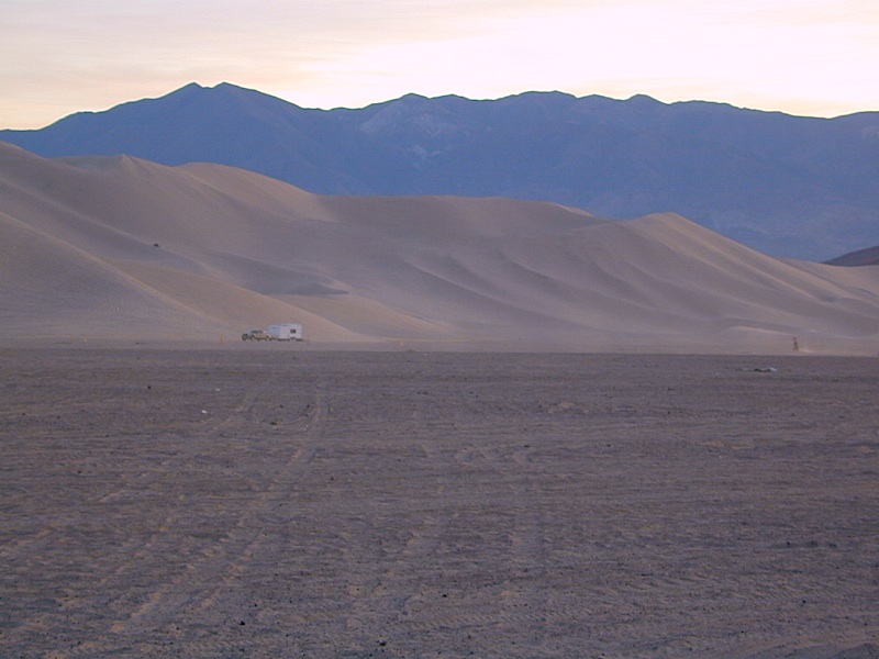
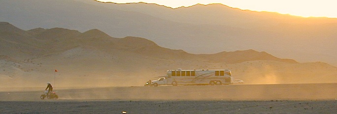
Sand dunes are popular spots for tourists, travelers, RVers and off-roaders. Death Valley National Park has many large areas for dunes, Mojave National Preserve has the Kelso Dunes.
Fortunately, those places do not allow driving on the dunes, which is exactly what the off-road boys want to do. Sand flying, motors screaming, music blasting, bon fires blazing and no silence found until the wee hours of early morning.
Autumn, Winter & Spring are the busy months for ‘froaders in the deserts, since summer temps can soar into triple digits heat daily.
Camping out near “the dunes” is usually a big, freaking, free-for-all, outdoors with the latest in motorized toys. Recreation Vehicles encircling bonfires (camp formation for a large group), toy box haulers, trailers, families, and maybe a massive BBQ setup.
OHV (off highway vehicle)
Vehicular Recreation Area
Below is a list of California Sand Dunes overseen by the Bureau of Land Management.
Arroyo Salado / Ocotillo Wells
Motorcycle, 4WD, ATV, Dune Buggy / Sand Rail
Located 10 mi. west of Highway 86 on Highway 78. Rolling hills and sand washes. Designated “Open Area” consisting of 4,800 acres. Adjacent to Ocotillo Wells Vehicular Recreation Area. Near Split Mountain, Anza Borrego Desert
Dumont Dunes Mojave
Motorcycle, 4WD, ATV, Dune Buggy / Sand Rail
Located 30 mi. north of Baker on Hwy 127, off Dumont Dunes Rd. Steep and tall sand dunes. Designated “Open Area” of 8,150 acres. South of Death Valley National Park.

Glamis / Gecko Road
Motorcycle, 4WD, ATV, Dune Buggy / Sand Rail
Holiday weekends = NUTS!! Approximately 22,000 acres. Located 25 mi. east of Brawley on HIGHWAY 78. Sand Dunes. Designated “Open Area” Danger: Adjacent to military bombing range. Contact the El Centro BLM
Imperial Sand Dunes / Buttercup Valley
Motorcycle, 4WD, ATV, Dune Buggy / Sand Rail
Approximately 11,000 acres. Located 10 mi. southeast of Niland on the Niland Glamis Rd. Sand Dunes are designated “Open Area”. Watch for closed area boundary at south end of area. CA Highway 78 near Brawley. Contact the El Centro BLM
Mojave El Mirage / Shadow Mountains
Motorcycle, 4WD, ATV, Dune Buggy / Sand Rail
Located 10 mi. west of Adelanto on Crippen/El Mirage Road. Dry lake Bed. Heavy use area. many non-motorized and motorized recreation – including aircrafts. Area consists of 24,000 acres.
Olancha Dunes OHV
Highway US 395 @ jct 190
Thousands of acres w/ open camping, located 5 miles from Hwy 395. In between Eastern Sierra range, Olancha & Death Valley National Park. Contact the Ridgecrest BLM
Plaster City / Yuha Basin
Motorcycle, 4WD, ATV, Dune Buggy / Sand Rail
South side of Anza Borrego Desert State Park. 15 mi. west of El Centro. Located on county Highway S-80. Consists of 41,000 acres of rolling hills and desert flats. Military bombing range north of area is closed to entry. Contact the El Centro BLM
Superstition Mountain
Motorcycle, 4WD, ATV, Dune Buggy / Sand Rail
Located 15 mi. NW of El Centro via Highway S-8, Huff, and Wheeler Roads. Varied terrain consisting of 13,000 acres; dry lakes, badlands, rocky mountains, and sand dunes. Military bombing range north and south of area is closed to entry. Contact the El Centro BLM
Rasor OHV Recreation Area
Motorcycle, 4WD, ATV, Dune Buggy / Sand Rail
Located 45 mi. northwest of Barstow, CA on Rasor Road. Sand washes and dunes, mesquite thickets. Designated “Open Area” consisting of 22,500 acres. Contact the Barstow BLM
Rice Valley Dunes
Motorcycle, 4WD, ATV, Dune Buggy / Sand Rail
Located 5 mi. south of Rice Valley off of Highway 62. Access is Santa Fe Road. Sand dunes. Designated “Open Area” consisting of 3,770 acres. Area of little use. Danger: Contaminated with unexploded ordinance.
![]()
![]()
![]()
![]()
![]()
see also California Coastal Dunes at Oceano: Pismo Dunes
Jawbone California | Desert Mohave | OHV ATV
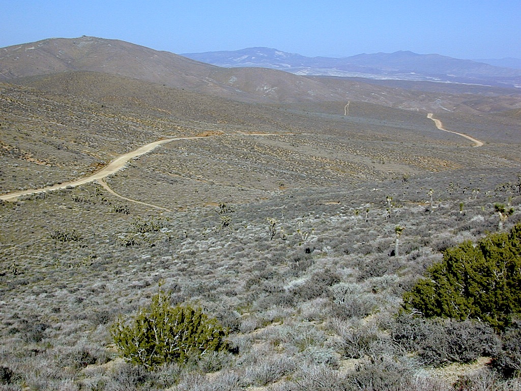
This is the North Mojave Desert, along Hwy 14, between the 395 junction & the town of MOJAVE CA. Jawbone Cyn is just south of Redrock Canyon State Park. Jawbone Canyon is big with off-roaders, so you’ll see plenty toy boxes & RVs w/ trailers out here. Open camping on desert washes; deep eroded canyons, minimal vegetation. The Dove Springs OHV area is closeby (on the other side of Red Rock, Randsburg ghost town is riding distance, and there is an information center & store w/ gas along the highway… Jawbone Store. 60 mph stretch. Blink & you will miss it.
Jawbone Canyon has open dispersed camping on dirt backroads. Many campsites suitable for motorhomes, toy boxes & trailers. Sandy washes & tight canyons are abundant. Very popular off-roading area, usually frequented by offroaders, ATV, dirt bikes & any other rig you can wheel. Busy on holiday weekends & very popular in winter months.
Jawbone Canyon dirt road climbs up from the rocky deserts to the joshua trees @ South Kelso Valley, passing the Bright Star Wilderness & Kelso Peak @ 5080′ elevation. The route eventually comes out at Hwy 178 just east of Lake Isabella, California. (This Kelso should not to be confused w/ Kelso, the train depot in the middle of the Mojave.)
Jawbone Store
Jawbone Information Center:
760-373-1146
There are many desert canyons to explore in this region. ATV, dirt bike, 4×4, or just a high clearance SUV will get you most places you wanna go. Routes include: Alphie Cyn, Butterbredt Cyn, Kelso Valley Rd, Dove Springs Canyon, Bird Springs Canyon, Horse Canyon, Last Chance Cyn, Sage Canyon & Cow Heaven Canyon. Bright Star Wilderness is back here near South Kelso Valley , but no OHV use is allowed on these precious peaks. Kelso Valley Road will lead past the Bright Star Wilderness, along Kelso Creek, up to Lake Isabella & Hwy 178 w/ the South Fork of the Kern River. See the photos in the Saabaru.
The dirt route thru Horse Canyon leads past joshua trees, climbing in elevation to pinyon pines, up to the Pacific Crest Trail along the Scodie Mountains & dead ends at the small, historic McIver Springs cabin w/ wood burning stove and is well worth the venture. (PCT intersects Hwy 178 at Walker Pass just a few miles North of here)
Across on the other side of the 395, is the Burro Schmidt Tunnel is hand dug oddity – way up behind Last Chance Canyon & is totally a family tourist destination these days.
 SDBKCO Recreation Map