a d v e r t i s e m e n t s

Destinations | Mountain

town.crowley lake

Crowley Lake

lodginglodging reservations in Crowley Lake

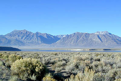
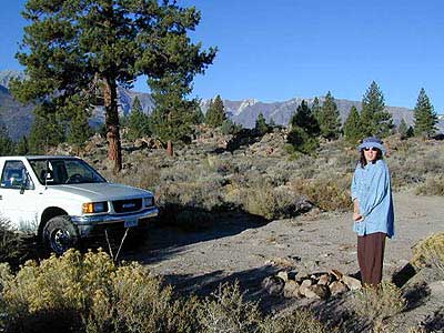
Crowley Lake & Tom's Place are located above the Volcanic Tableland (Sherwin Grade) that climbs north outta Bishop & parallels Rock Creek. The lake is well known for it's prime fishing & primitive secluded RV camping on the east side. The views of the Sierra Nevada are incredible from this location. Aspen trees in the region are a splendid sight in Autumn.
elevation: 6781' population: 6,781 zip code: 93546

Mountain

terrain:
high desert reservoir, right next to Sierra Nevada range

location:
N of Bishop
on Hwy 395

maps


recreation:

  • backpacking
  • biking
  • boating
  • fishing
  • hiking
  • kayaking
  • camping
  • RV camps
  • indian petroglyphs
  • Mountain Biking
  • Snow Skiing
  • Rock Climbing -Owens River Gorge
  • Primitive Hot Springs
  • parks, forests, rivers & lakes:

  • Inyo National Forest
  • John Muir Wilderness
  • Fish Slough
  • Convict Lake
  • Mono Lake
  • Owens River
  • Eastern Sierra Nevada Forests Map Set
    Eastern Sierra Nevada Forests Map Set

    Campgrounds campground reservations
    To make a campground reservation nearby click below

    McGee Creek Campground
    French Camp - Eastern Sierra Camping
    RV Crowley - Lower Rock Creek
    BLM Campgrounds - Crowley Lake
    Crowley Lake RV Park

    tent camping

    description:
    Large reservoir on the edge of the tablelands in the Bishop Eastern Sierra region. This lunar landscape surrounding the lake - with little to no trees, but the breathtaking views of the magestic Sierra's make up for this fact.

    nearby towns:
    Tom's Place
    Bishop
    Round Valley (Inyo Co.)
    Mammoth Lakes
    Benton
    Convict Lake
    local links:

    Bishop Chamber of Commerce & Visitors Bureau
    690 N. Main St. Bishop, CA 93514
    760-873-8405
    888-395-3952
    http://www.bishopvisitor.com

    Topo Zone Lake Crowley
    Owens Gorge Rock Climbing
    Views from Eastside Camps
    Total Escape Campsite
    Local Photographer
    Long Valley Caldera
    Eastern Sierra - Highway 395

    Advertise on this site
    John Muir Trail Maps (set)
    John Muir Trail Maps (set)
    Inyo National Forest Map
    Inyo National Forest Map
    Bishop Pass Map
    Bishop Pass Map
    John Muir Wilderness / Kings Cyn Map
    John Muir Wilderness / Kings Cyn Map
    Devils Postpile Trail Map
    Devils Postpile Trail Map
    Search : California Desert Byways: 68 of California's Best Backcountry Drives
    California Desert Byways: 68 of California's Best Backcountry Drives

    Amazon.com's Price: $12.89
    Search : Utah Byways: 65 of Utah's Best Backcountry Drives
    Utah Byways: 65 of Utah's Best Backcountry Drives

    Amazon.com's Price: $12.89
    Search : California Coastal Byways: 50 of California's Best Backcountry Drives (Byways)
    California Coastal Byways: 50 of California's Best Backcountry Drives (Byways)

    Amazon.com's Price: $12.89
    Search : Sierra Nevada Byways: Backcountry Drives for the Whole Family
    Sierra Nevada Byways: Backcountry Drives for the Whole Family

    Amazon.com's Price: $12.89
    Search : Oregon Byways (Tony Huegel's Backcountry Byways Series)
    Oregon Byways (Tony Huegel's Backcountry Byways Series)

    Amazon.com's Price: $16.95


    California Weekends
    Copyright © 1996-2008 Total Escape, www.totalescape.com / All Rights Reserved.

    home | lodge | recreation | destinations | journey | forum | trips | advertise | site map | outside | maps | gear


    Accessoriesbutton


    MCSS_Offroad_120x240