Advertisement
Journey | Time
| Destinations
time
line
driving guide
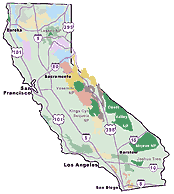
View Larger Map
|
Nothing can destroy a fun filled road trip easier than
spending 80% of it driving to your destination.
You are stressed from the work week, tired from the long drive, your nerves are shot & everyone is now grumpy. What a way to start a vacation!
planning for easy departure:
- the week before
Pack & do laundry, grocery shop for trip; pack toiletries, drinking water, beverages, snacks, food and any gear ahead of time. Make a big stack of your stuff in one spot and keep adding to it. Physically pack the duffle bags, carry bags and backpacks one day before departure.
- study your maps
No time for televsion now - you are gonna hit the road in just a few days. You need to know where you are going and what cool destinations are to follow. Examine the maps and terrain. Plan your route online & off. Nothing beats good, old fashioned, printed topographic maps (a real hardcopy)
- leave early
Take an extra day off of work before a 3 day weekend and turn the road trip into a full 4 day luxury vacation. Leaving midday may put you in busy traffic in the metro areas. Plan for a 'night before' departure if possible; driving at night means less traffic. You can stay overnight in route (budget hotel or camp).
- online planning tip
The easiest way to plan a California road trip is to research your travel distances online in advance. Web sites like Google Maps, Yahoo Maps, or MapQuest can help in determine your route and study the local terrain. Whatever you do: DO NOT RELY on these printed (online) maps alone. If you hit the road with only a one page print out without carrying any other types of regional maps you may be in for a frustrating or longer route, or miss everything by taking only freeways. Don't count on any good cell phone coverage in rural regions, much less a digital 4G network.
.
|

|
|
 rule of thumb:
For every 2 hours of driving
time, Stay a minimum of one overnight!
This means if you are traveling from San Diego to Big
Bear
, on average it will take about 2-3 hours drive one way, which
means one single overnight stay (be it lodge, cabin or camping) is not unheard of.
But if you are planning to visit Mammoth from Los
Angeles
, it is more like 4-6 hour drive & you better be spending
at least 2 or 3 nights up there to get your precious vested time worth.
This line of thought on preparation and planning helps you rest, relax and enjoy your time off - away from the city. Some folks are too scared to leave the comfort of a city and that's just fine. Let them have it.
California
is the LEFT COAST, the west coast, a long state, a tall region; driving North-South routes can be very time consuming.
samples:
San Diego
to Yosemite is 8 hours worth of travel time.
Los Angeles to Shasta is a whopping 12 hours
drive.
Do not strictly rely on GoogleMaps for drive time estimates; use them for planning purposes but realize other factors may add additional time. Buffering long road trip travel time with an extra hour or two to include gas stops, lunch breaks, stretch breaks, bathroom stops and any possible traffic jams you might encounter.
see California
Mileage Chart
below for reference
varied routes: If you are planning a multiple stop trip or even
trying to get an exact route down, web sites like GoogleMaps and MapQuest may make you enter in several smaller towns along the way
to get an accurate or preferred highway. And if ya got plenty
of time to take the BackRoads
we highly recommend a California Benchmark Map.
|
There once was a couple from the OC, who headed east outta town with glee. As they climbed into the hills, beauty and sunset held many thrills. Ended up lost in the mountains, in the dark, finding a small town Julian, where luckily they were able to stop and ask for directions. DanaMite gave them some added advice: Make sure the next trip you have a real map, not just a one page print out from online. They spent their time frantically looking for Interstate 10 (the long way through the hills). Christmas Eve spent driving and mad, instead of by a fireplace & relaxing.
CAL TRANS HWY INFO:
800-427-7623
All hours of the night & day you
can find the California Dept. of Transportation closing
roads & freeways. Just for peace of mind: Call ahead, especially
for mountain routes & snowy winter conditions.
|
|
city traffic
jams:
Such is life in the
big city! Welcome to California hell traffic. Large urban centers
such as Sacramento, Fresno, Los Angeles, San Diego & San Francisco Bay area traffic
is difficult to judge, so a visit various web sites a few days
in advance to check traffic patterns of local commuters. Plus
check out the Traffic Page for tips on easing your weekend get-a-way
.
|
up to minute traffic reports online - check it before you start your drive!
|
|
Overnight 'on the way' stops can be found anywhere
& if the weather is decent you can always pitch a tent. Good
overnight stops heading northbound from SoCal include:
Coastal Route -
Hwy. 101:
Cheap
hotels & coastlines rarely go together, but these are your best
bets - Oxnard, Ventura,
Buellton,
Los Alamos,
Santa Maria
Pismo,
& as far north as San
Luis Obispo
.
campers
- should try any of the State Beaches along the Santa Barbara
coastline or a Los
Padres National Forest Map
. Free campgrounds are hidden well
behind Solvang
& Santa Maria
Central Valley -
Interstate 5:
Central
Valley hotels - Buttonwillow, Kettleman City or Coalinga area motels.
Hwy. 99: Bakersfield
thru Tulare - cheap hotels abundant along this route.
campers - Not too many camping options
in the Central Valley, except an RV park every now & then.
Try a Los
Padres National Forest Map
or Sequoia Map for all decent campgrounds.
Mojave/ Eastern
Sierra -
Hwy 395:
numerous lodging options along this route Randsburg, Olancha, Lone Pine, Independence, Big Pine, Bishop, Mammoth, June Lake, Lee Vining, Bridgeport, up to Lake Tahoe
campers - should try forest camps in Inyo
National Forest
or desert camping at Red
Rock State Park
|
|
 Shop
for your travel & outdoor gear online, instead of wasting
time driving around town all week trying to find that perfect
item:
Shop
for your travel & outdoor gear online, instead of wasting
time driving around town all week trying to find that perfect
item:
|
totalescape.com/gear
|
|
Miles
|
Distance between popular California
Cities
|
Kilometers
|
|
| |
|
|
|
|
|
|
|
|
|
|
|
|
Barstow |
Bishop |
Eureka |
Fresno |
LA
|
Needles |
Palm Spr |
Redding |
Sacr |
SD |
SF
|
| Barstow |
-
|
215 |
685 |
245 |
115 |
145 |
125 |
575 |
415 |
175 |
420 |
| Bishop |
350 |
-
|
560 |
225 |
265 |
360 |
300 |
435 |
270 |
355 |
295 |
| Eureka |
1100 |
900 |
-
|
450 |
645 |
825 |
750 |
145 |
290 |
765 |
275 |
| Fresno |
390 |
360 |
725 |
-
|
220 |
385 |
325 |
335 |
170 |
340 |
190 |
| LA |
185 |
430 |
1040 |
350 |
-
|
260 |
110 |
545 |
385 |
125 |
385 |
| Needles |
230 |
575 |
1330 |
620 |
415 |
-
|
210 |
715 |
55 |
320 |
560 |
| Palm Spr |
200 |
485 |
1210 |
520 |
175 |
335 |
-
|
650 |
490 |
140 |
485 |
| Redding |
925 |
695 |
235 |
535 |
880 |
1150 |
1045 |
-
|
165 |
665 |
215 |
| Sacramento |
665 |
440 |
645 |
275 |
620 |
895 |
790 |
260 |
-
|
505 |
85 |
| San Diego |
285 |
570 |
1235 |
545 |
200 |
515 |
225 |
1070 |
815 |
-
|
505 |
| San Francisco |
675 |
475 |
440 |
300 |
615 |
900 |
785 |
350 |
135 |
815 |
-
|
Most importantly, pleas bookmark this site https://totalescape.com
to plan your trips & find outdoor recreation. DanaMite has kept Total Escape online 17 years and counting!
|
Total Escape California Camping
Advertisement
|
|


