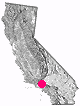
Mount Pinos and Frazier Mountain are located in between the huge, urban Los Angeles and the California Central Valley. Dirt bike trails, 4x4 routes, forest car camping, backpacking, and OHV parks all nearby.

 by county
coastal
deserts
urban
mountains
countryside
snow towns
parks & forests
cali maps
by county
coastal
deserts
urban
mountains
countryside
snow towns
parks & forests
cali maps
Mount Pinos and Frazier Mountain are located in between the huge, urban Los Angeles and the California Central Valley. Dirt bike trails, 4x4 routes, forest car camping, backpacking, and OHV parks all nearby.
frazier park, California
![]() Mountain
Mountain
![]()
recreation:
parks, forests, rivers & lakes:
frazier park campgrounds
Pyramid Lake Camping
McGill Campground - Mt Pinos
Ojai Camping
Mount Pinos Camping
Frazier Park Camping
Toad Spring Campground
Reyes Creek Campground
Caballo Campground
Campo Alto Campground
Chuchupate Campground
Chula Vista Walk-in Camp
Dome Springs Campground
Santa Lucia Camping

description:
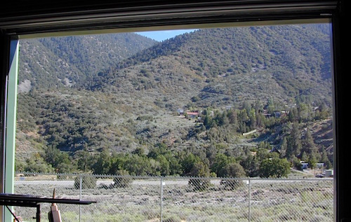
Nothing too spectacular about the main drag in Crazier Park, just a few local biz - eateries, bars and the basics.
La Sierra is a decent Mexican food stop and High Mountain Market serves freshly made hummus and dolmas (stuffed grape leaves). That's as much culture as you're gonna get up on this mountain.
This place is a little rough around the edges. Rednecks, ranchers, rangers, parolees, and mountain folk all call this place home.
Frazier Chamber of Commerce
3717 Mount Pinos Way, Frazier Park, CA 93225
661-245-1212
https://www.mymountainchamber.com/
Cuddy Cam
Working Wildlife
Tejon Ranch Conservancy
Real Kern County
Los Padres Forest Watch
Mt Pinos Clear Sky Chart
Peak to Peak 8000' Hike
Fiesta Days in Frazier Park
Quatal Canyon 9N09
Cherry Creek 4x4 Trail
Frazier Park Camping
Route #7N23 – Angeles NF
Tejon California
Los Angeles Back Roads
Sespe Wilderness Trail Map
Los Padres Forest Topo Atlas
Los Padres National Forest Map
La Sierra Mexican Restaurant
Red Dot Vegetarian Kitchen
Big John's Mountain Grill
Frazier Park Market
Sue's Tavern
Frazier Park Car Wash


Advertisement


Total Escape has been an AmazonAssociate for 20 years!
Earnings from purchases keeps this site alive.
Copyright © 1996-2024 Total Escape, totalescape.com / All Rights Reserved.
classic | lodge | recreation | destinations | journey | ads | sitemap | outside | maps | gear | mobile